

bigpigeon.us webpage WWII Japan > CBI Theater > Crossing the Hump, © 2024 by Robert A. Christiansen, edited by RAC 15 Feb 2024.
This webpage ties in with the other three China-Burma-India Theater webpages, namely China, India, and Burma.
"it is of the utmost urgency that the pathway to China be kept open" - President Franklin Roosevelt to General George Marshall, 25 Feb 1942.
This webpage ties in with the other three China-Burma-India Theater webpages, namely China, India, and Burma.
"it is of the utmost urgency that the pathway to China be kept open" - President Franklin Roosevelt to General George Marshall, 25 Feb 1942.
Crossing the Hump - Overview
The Republic of China was one of the major Allied combatants during the War with Japan. Herein I summarize the Allies' land and air links into China that supported the Chinese government, the Chinese military, and the limited US military presence in China. Aid sent through these links helped tie up much of the Japanese Imperial Army in the Chinese interior rather than killing Americans in the Pacific Theater.
|
After this overview, the Crossing the Hump webpage has three parts:
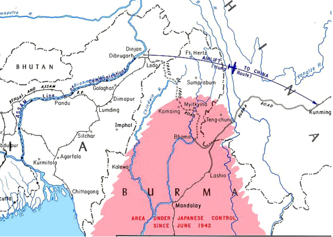
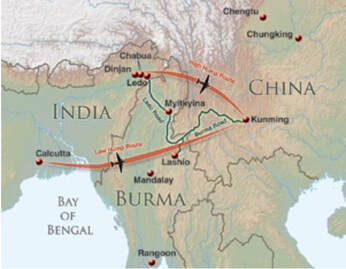
Before the Japanese captured southern Burma in early 1942, shipments to China over the Burma Road came north from ports in the Rangoon, Burma area by rail to the railhead at Lashio. After the capture of Burma, shipments to China came north from ports in the Calcutta, India area via rail to railheads in Assam in extreme northeast India in the area shown by a cluster of airfields on the second map. Whether by road or air, the China lifeline crossed multiple mountain ranges, of which those in India were part of the Hengduan Mountains. The Burma and Ledo roads skirted to the south of the worst of the mountains. To avoid attack from the air, the Hump airlift had to fly further north, where the mountains were higher and the weather was worse. |
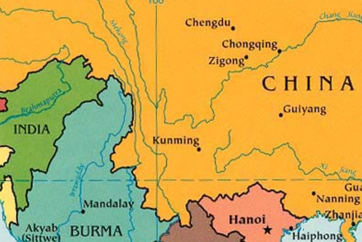
Southwest China Area

The World War II Hump Area
|
|
The Hengduan Mountains shown in the accompanying map are a series of generally north-south mountain ranges separated by deep gorges that contain several of the greatest rivers of southeast and east Asia; the Salween, Mekong, and Yangtze. The Hengduan Mountains decrease in height as they descend south from the Tibetan Plateau. The westmost range, between the Salween and Mekong Rivers, is especially formidable.
|
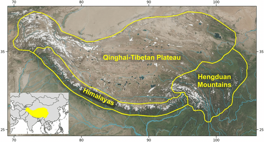
The Hump airlift flew southeast across the lower right corner of this map.
|
Please note: Despite what is commonly written, the Hump airlift did not fly over the Himalaya Mountains. The higher Himalaya Mountains run west to east between India and the Tibetan Plateau. The Hump airlift flew over the southern end of the Hengduan Mountains, which hang off of the southeast edge of the Tibetan Plateau, to the east of the Himalayas.
Part 1 - The Burma Road, 1938-42
|
The Japanese Imperial Army occupied large areas of China in 1937 and 1938, including most coastal ports.
In September 1940, Japanese troops occupied the north of the Vichy French colony of French Indo-China, severing the links from Haiphong into unoccupied China shown on the accompanying map. Thus, after September 1940 the only link from the Western Allies into China was:
In January 1942, Japan invaded Burma and on 1 March British Empire forces abandoned Rangoon. Japanese forces then advanced into northern Burma, capturing Lashio on 29 April, and continuing northward until all but extreme northern Burma was Japanese-controlled. The last Allied link to China was now broken. However, President Roosevelt had directed that a new route be found. Kumning in Yunnan, China remained the natural choice for the terminus of the new route. |
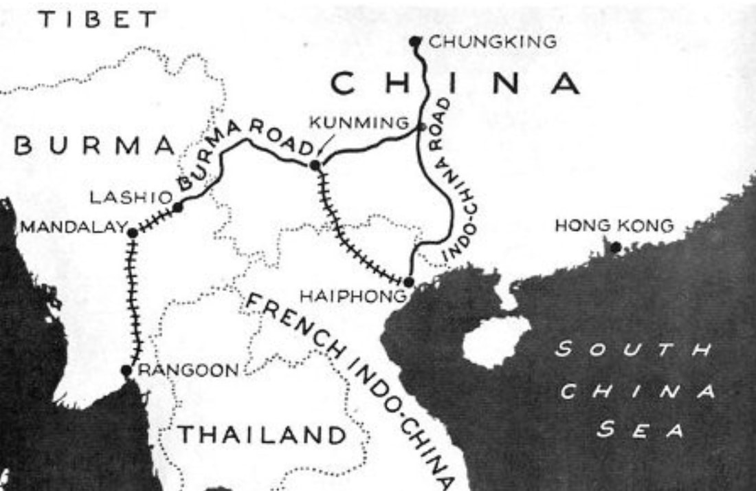
The Burma Road
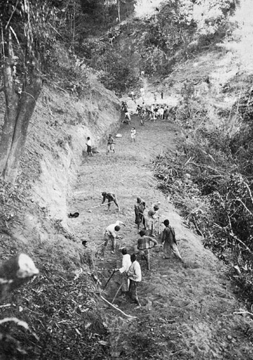
Building the Burma Road, 1938
|
Part 2 - The Hump Airlift - India to China, 1942-45
|
In early 1942, with the last land route to China rapidly closing, planning began on opening an air route. The air route that developed was called the Hump.
A recently-bult British airfield at Dinjan was initially used, with the first flight on 8 April 1942. The next airfield built was at Chabua. The second map shows:
|
WW II Supply Line to China - 1942-45 via the Hump Airlift
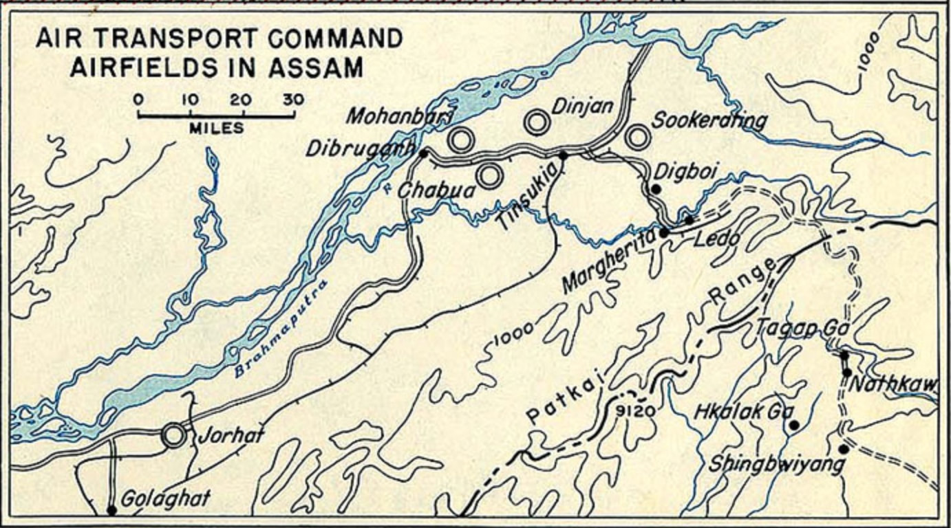
Hump Airfields in Northern Assam
|
|
Although Hump airlift operations began in mid 1942, infrastructure deficiencies in northeast India and limited American resources kept the Hump operation from reaching its goals until December 1943.
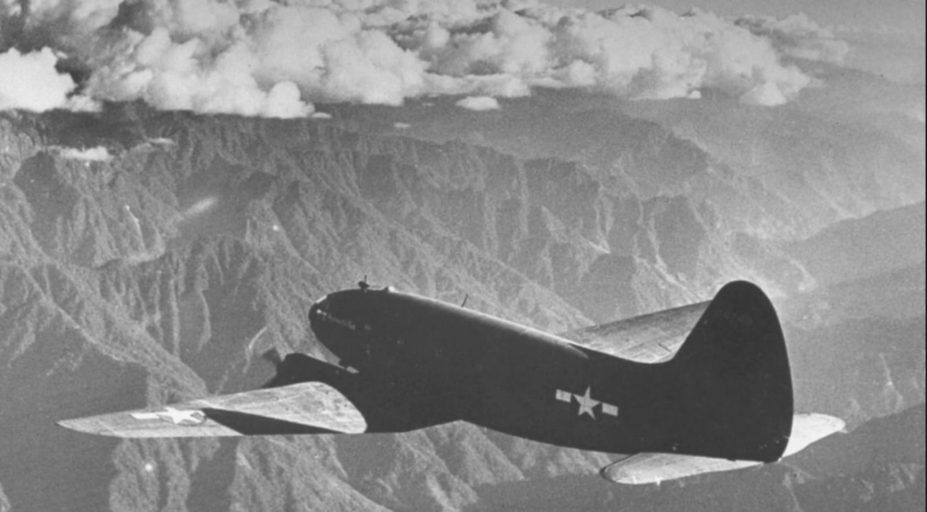
The Tenth Air Force ran the Hump airlift until December 1942, when operation was transferred to the Air Transport Command. Concurrently with the US airlift was a much-smaller airlift by the China National Aviation Corporation. Much of the cargo carried by the Air Transport Command over the Hump supported the Fourteenth Air Force, the primary US military unit in China. For the first two years of its operation, Hump pilots had to fly the High Hump route over 15,000 foot ranges plagued with foul weather. In mid-1944, an Allied land offensive in north Burma reduced the threat from Japanese aircraft, and the Low Hump route shown on the accompanying map became a possible option. The Air Transport Command lost about 600 aircraft in the Hump airlift, with about 1,500 air crew deaths. It moved about 650,000 tons of cargo over the Hump from India to China. |
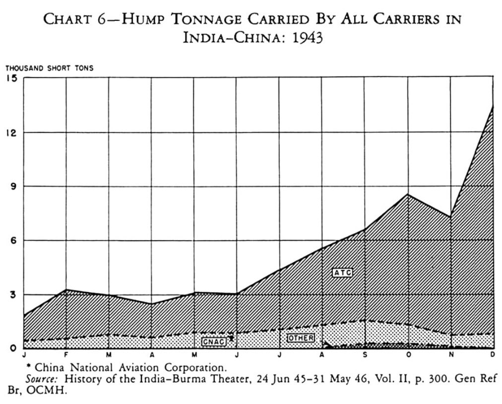
Hump Tonnage 1943
The Low Hump Route
|
Postscript: Early in the Cold War five years later, between June 1948 and May 1949, the Air Transport Command flew 2.3 million tons of cargo into West Berlin during the Berlin Blockade. The Hump airlift experience was invaluable in organizing and operating the massive Berlin airlift.
Part 3 - The Ledo/Stilwell Road
|
The Ledo Road began at Ledo in Assam, India and ran through northern Burma in a generally southeast direction until connecting with the Burma Road near the Chinese border.
Although officially the Ledo Road, it is often called the Stilwell Road in honor of General Joseph "Vinegar Joe" Stilwell, the acerbic US commander in Burma and China from early 1942 until October 1944. US Army Engineer battalions and thousands of local laborers built the Ledo road. Like many large Army Engineer projects in WW II, a goodly part of the workforce consisted of Black battalions. The Ledo Road eventually connected the Ledo railhead in extreme northeastern India with the Burma Road near the Chinese border at Wanting, 500 road miles to the southeast. Construction began at Ledo in December 1942 and was completed around the end of 1944.
The first Ledo Road convoy to China of 113 vehicles left Ledo on 12 January 1945 and arrived in Kumning, China on 4/5 February (WW II dates often differ by a day for events west of the International Date Line). The convoy was held up for about ten days because of lingering Japanese resistance. During its use in 1945, the Ledo-Burma road carried to China about 1/10 of the total tonnage that was carried by air over the Hump in the 1942-45 airlift. However, the Ledo Road also supported Allied ground operations in northern Burma and a fuel line along the road provided gasoline into the interior of Burma. Both the Ledo and Burma Roads were prone to washout, being built in mountainous areas containing major rivers that experienced heavy monsoon rainfall. After WW II ended, portions of both soon fell into disrepair, although there are recent restoration efforts. |
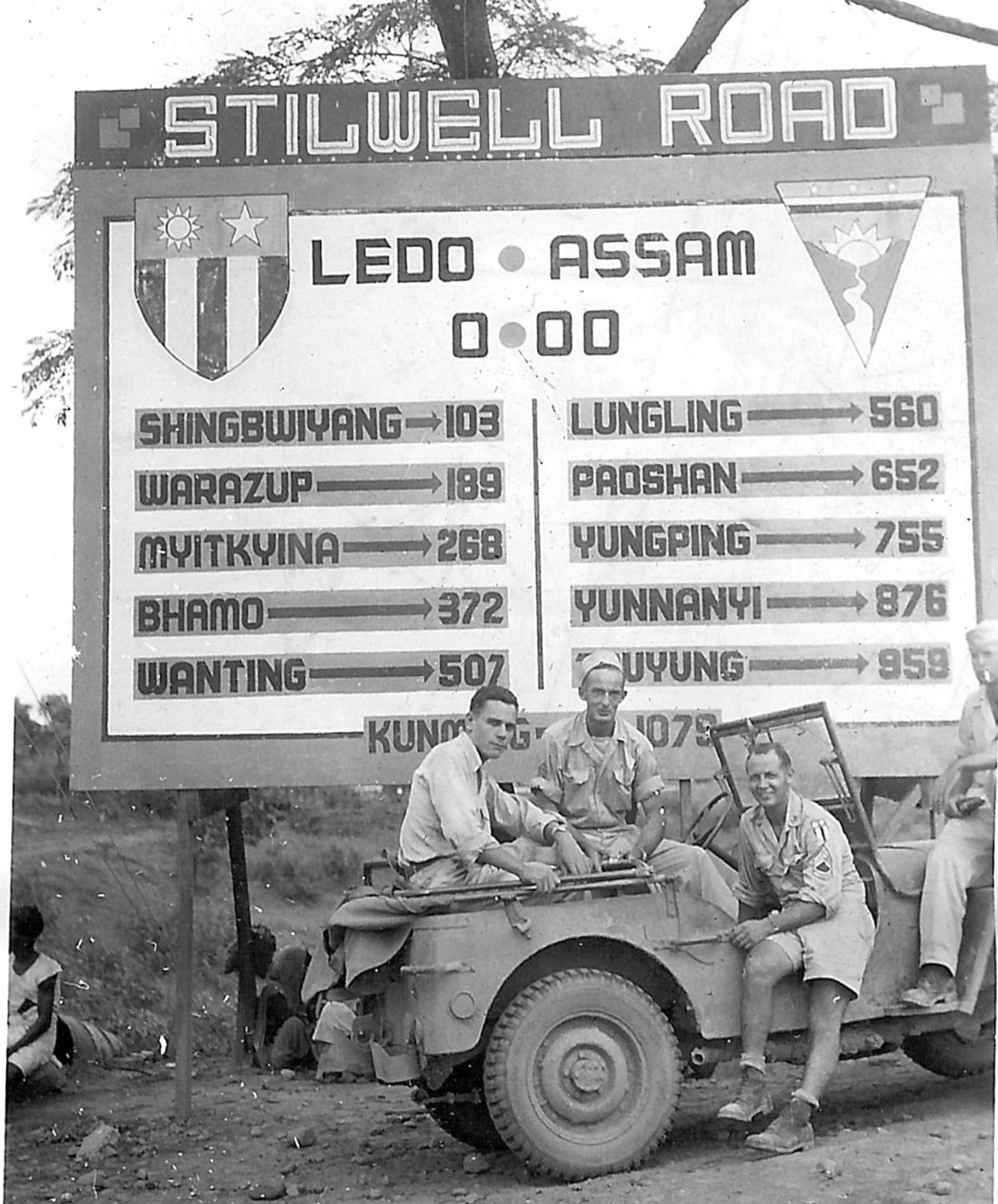
The 1,079-mile Ledo/Stilwell Road at Mile Zero, 1945
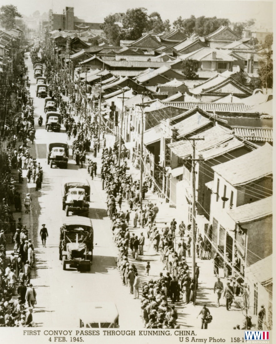
The First Convoy from Ledo Arriving in Kumning
|
Sources for Big Pigeon's CBI Theater > Crossing the Hump webpage:
Pottawattamie Area WWII Dead - CBI Theater > Crossing the Hump:
† Finley, Clyde Clem Jr., SN T-004898, US Army Air Force, Harrison Co.
- The webpage header photo, Flying the Hump, is courtesy of historicaltruth101.com.
- The Southwest China Area map is taken from the 2003 CIA political map of Asia and was found at https://sites.middlebury.edu/southchinasea/files/2011/08/Southeast-Asia-Political-Map-CIA-2003.jpg.
- The World War II Hump Area map was found at https://travelthehimalayas.com/kiki/the-stilwell-road.
- The Hump airlift flew southeast map ... is courtesy of Yawou Xing at https://www.researchgate.net/figure/Map-of-the-Hengduan-Mountains-region-in-relation-to-the-QTP-and-Himalayas_fig2_315791055.
- The Burma Road map comes from U.S. Army Center of Military History via Wikimedia Commons and was found at https://www.dangerousroads.org/asia/china/321-burma-road-china.html.
- The Building the Burma Road, 1938 map is courtesy of https://conservapedia.com/images/4/4e/Cbi-roadwork.jpg.
- Background info: https://www.historynet.com/over-the-hump.htm is a well-written acccount of the Hump airlift.
- Background info: https://everything.explained.today/India-China_Division%2C_Air_Transport_Command/ lists the units involved and airfields used in the Hump airlift.
- The WW II - Supply Line to China 1942-45 via the Hump Airlift map is courtesy of http://iloveww2warbirds.com/wp/wp-content/uploads/2015/07/Hump-Map.jpg.
- The Hump Airfields in Northern Assam, India in WW II map is courtesy of http://www.firebirds.org/menu1/coleson3c.htm.
- The Hump Tonnage 1943 chart is courtesy of the Pacific War On-line Encyclopedia at https://pwencycl.kgbudge.com.
- The Low Hump Route map is courtesy of https://www.warhistoryonline.com/guest-bloggers/guess-wwiis-biggest-airlift-hump.html.
- The Ledo/Stilwell Road at Mile Zero map is courtesy of https://en.wikipedia.org/wiki/Ledo_Road.
- The First Convoy from Ledo Arriving in Kumning photo is courtesy of https://www.ww2online.org/image/chinese-civilans-watching-convoy-us-army-trucks-driving-down-kunming-china-1945.
- Background info: https://www.cbi-theater.com/ledoroad/Story_firstconvoy.html by William B. Sinclair is an interesting story of the first convoy over the Ledo road to Kumning.
Pottawattamie Area WWII Dead - CBI Theater > Crossing the Hump:
- Taken from the bigpigeon.us WWII Dead module.
† Finley, Clyde Clem Jr., SN T-004898, US Army Air Force, Harrison Co.
- 1333rd Base Unit, India-China Division, Air Transport Command, based at Chubua, Assam, India; Curtiss C-46A-5-CK Commando #43-47003 co-pilot; DNB 31 Aug 1945 in Assam, India; aircraft crashed on flight from Kumning, China to Chabua; initially buried at crash site 56 km NW of Dibrugarh-Chabua Airport.
- 6th Ferrying Sqdn., 1st Ferrying Gp., India-China Wing, Air Transport Command, based at Mohanbari, Assam, India; Douglas C-47 Skytrain/Dakota #41-38656 radio operator; DNB 2 Aug 1943 near Yunnanyi, west of Kumning, China on return cargo flight from Kumning to Mohanbari.
- 78th Transport Sqdn., 22nd Transport Group, India-China Wing, Air Transport Command, based at Jorhat, Assam, India; Consolidated C-87 Liberator Express # 41-11908 crew chief wit pilot Hartvig Larsen of Omaha; DNB 10 Sep 1943 on flight from Jorhat to Kumning, China; aircraft crashed in Hukawng Valley, Burma; BNR.
- Bn. Headquarters, 445th Signal Construction Bn., Aviation (colored); DNB 19 Oct 1944 in Burma or India; passenger on Douglas C-47 Skytrain/Dakota flight from Myitkyina, Burma to Ledo, Assam, India; aircraft disappeared after requesting a heading to Ledo; BNR.