
bigpigeon.us webpage WWII Dead > Residences, © 2023 by Robert A. Christiansen, updated by RAC 27 Dec 2023.
The Home Locations of the Pottawattamie Area WWII Dead
Those listed in Big Pigeon's WWII Dead > Roster Records or WWII Dead > Ancillary Records submodules appear in one or two of the twelve Residences webpages listed below.
The Home Locations of the Pottawattamie Area WWII Dead
Those listed in Big Pigeon's WWII Dead > Roster Records or WWII Dead > Ancillary Records submodules appear in one or two of the twelve Residences webpages listed below.
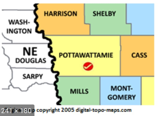
- Council Bluffs - held over half the population of Pottawattamie County.
- Rural Pottawattamie County - the remainder of Pottawattamie County.
- Audubon County - east of Shelby County.
- Cass County - east of Pottawattamie County.
- Harrison County - north of Pottawattamie County.
- Mills County - south of Pottawattamie County.
- Montgomery County - south of Pottawattamie County & east of Mills County.
- Shelby County - north of Pottawattamie County & east of Harrison County.
- Other Southwest Iowa Counties - some WWII deaths from 12 other counties.
- Remaining Iowa Counties - some WWII deaths from the 80 remaining Iowa counties.
- Iowa's Six Border States - some WWII deaths from Illinois, Minnesota, Missouri, Nebraska, South Dakota, & Wisconsin.
- Remaining States - some WWII deaths from the 43 remaining states; California was far the most common.
- Some list entries are not yet complete; list entries will eventually consist of the heading lines of roster records (name, service number, service branch, counties).
- Webpages 2-8, for Pottawattamie area counties, are organized by town.
- The lists of names in webpages 1-8 are nearly complete.
- Webpages 9-12 will remain very fragmentary and are organized by counties.
- "vet" denotes a WWII veteran who died after separation from service and before eligibility for WWII veterans' bonuses expired in 1950. Full records for these veterans are not in WWII Dead > Roster Records webpages but rather in the WWII Dead > Ancillary Records webpages.
Some roster members are included in two of the twelve lists for several reasons:
- I sometimes learned from census records, obituaries, or family histories that the roster member had lived for considerable periods of time in two counties.
- I included the home county as given in the 1946 War and Navy Departments lists of WWII dead or in county honor lists of WWII dead. Sometimes this was at variance with what one would otherwise expect to be the home county.
- WWII decedents who happened to live near a county border were often viewed as being from a nearby town in the adjoining county. I have attempted to include both counties.
- The decedent may have lived elsewhere but had parents or spouse living in a Pottawattamie area county.
Links to my other webpages or reports containing information about roster members home locations:
- Council Bluffs Abraham Lincoln High School WWII Dead - report listing dead from the 1946 ALHS yearbook.
- Gold Star Avoca - Big Pigeon webpage - deaths from all wars for Avoca, Iowa.
- St. Paul's - report listing all WWII veterans of St. Paul's Lutheran Church, Boomer/Neola.
- WWII Dead - Allied Family Members - out-of-date report, mostly relatives of my uncles and aunts.
Sources for Big Pigeon's WWII Dead > Residences subpages
Images used on this page:
- Pottawattamie Area, the page header index map, is courtesy of familysearch.org.
- Council Bluffs - the 1942 Council Bluffs - Omaha map is courtesy of https://www.aaroads.com/nebraska/omaha/#iLightbox[image_carousel_1]/1, which also has 1956 and 1965 maps.
- Rural Pottawattamie County -
- Audubon County -
- Cass County - the c. 1930 county map is taken from the Iowa Digital Library's Montgomery Co. Hixson atlas.
- Harrison County - the Harrison County map is courtesy of iagenweb.org/harrison.
- Mills County - the Mills County map is courtesy of iagenweb.org/mills.
- Montgomery County - header image found at http://iagenweb.org/montgomery/photos/1930mapMontgo.jpg
- Shelby County - the Shelby County map is courtesy of rootsweb.com/~iashelb.
- Other SW Iowa Counties
- Other Iowa Counties
- Iowa's Six Border States - the Midwestern US map is courtesy of https://www.britannica.com/place/Midwest.
- Other States:
- The California Counties map is courtesy of the California State Association of Counties.
- The Missouri Counties and County Seats map is courtesy of geology.com.
- The Nebraska Counties map is courtesy of www.siteatlas.com.