Big Pigeon in Southwest Iowa
  • Home
    • Usage Hints
    • Acknowledgments
    • Resources >
      • Free Sites
      • Pay Sites
      • Print Resources
      • Search Engines
      • Land Records
      • Resources - Denmark >
        • Finding Danish Ancestors
    • Project Mgt - Public >
      • Website Overview
      • Website Log
      • Project Overview
      • Mac Computer Use
      • Weebly Use
      • Reunion Use
      • Project History
      • Image Provenance
    • Project Mgt - Private >
      • Site Management
      • Site Plan
      • Contact List
      • Backup Info & Log
      • System Info & Log
      • Image Storage
      • E-Mail Log
      • Asset Organization
      • History Index
      • Binders & Photos
      • Upon My Death
      • Donations & Dispersal
  • Family
    • Photos - Recent
    • Christiansen
    • Rasmussen
    • Christiansen/Rasmussen News
    • Larsen/Larson
    • Hansen
    • Larsen/Hansen News
    • Allied Families
    • Wall of Honor
  • St. Paul's
    • Early Families >
      • Early Families Help
      • Early Families More Lists
    • St. Paul's Roots
    • St. Paul's Timeline
    • St. Paul's Resources
  • History
    • Iowa History >
      • The Missouri River
      • The Native Americans
      • The Colonial Period
      • The Louisiana Purchase
      • Iowa Land Cessions
    • SW Iowa History >
      • The Corps of Discovery
      • Middle Missouri Fur Trade
      • Yellowstone Expedition
      • The Potawatomi Years
      • The Mormon Years
      • Political Organization
      • Population Data
      • Transportation Maps
    • Pott. Co. History
    • Big Pigeon Area >
      • Nearby Towns >
        • Beebeetown
        • Crescent
        • Honey Creeek
        • Loveland
        • Neola
        • Persia
        • Underwood
        • Weston
        • Lost Locales
      • Danes from Dronninglund
      • Maps & Plats
      • Big Pigeon Galleries >
        • Gallery 1 - Area Historic Structures
        • Gallery 2 - Grange Sunday School
    • Avoca >
      • Gold Star Avoca
      • Cuppy's Grove
    • LDS History >
      • LDS Links
      • Gallery 1 - Mormon Maps
    • A House Divided >
      • Endnotes
      • Niels Peder Pedersen
      • Ane Katrine Pedersen
      • Kirsten Pedersen
      • Kirsten's Story >
        • Kirsten's LDS Daughters
        • Kirsten's Daughter, Karen Bondo
        • Kirsten's Son, Anders Johnson
        • Kirsten's Niece, Christine Mortensen
        • Kirsten's Niece, Anne Marie Larsen
    • More History >
      • Pott. Co. Addendum
      • American History
  • WWII Roster
    • Roster Records >
      • Roster A
      • Roster Ba-Bm
      • Roster Bn-Bz
      • Roster Ca-Cm
      • Roster Cn-Cz
      • Roster D
      • Roster E-F
      • Roster G
      • Roster Ha-He
      • Roster Hf-Hz
      • Roster I-J
      • Roster K
      • Roster L
      • Roster Ma-Mm
      • Roster Mn-Mz
      • Roster N-O
      • Roster P
      • Roster Q-R
      • Roster Sa-Sm
      • Roster Sn-Sz
      • Roster T-U-V
      • Roster Wa-We
      • Roster Wf-Wz
      • Roster X-Y-Z
    • Ancillary Records >
      • Veterans A-M
      • Veterans N-Z
      • More WWII Era Dead
    • Member Residences >
      • Council Bluffs
      • Rural Pott. Co.
      • Audubon Co.
      • Cass Co.
      • Harrison Co.
      • Mills Co.
      • Montgomery Co.
      • Shelby Co.
      • Other SW Iowa Counties
      • Other Iowa Counties
      • StatesBorderingIowa
      • Other States
    • Land, Air, Sea Dead >
      • Land Dead >
        • Division Dead - Japan
        • Division Dead - Germany
        • Other Land Dead
      • The Air Dead
      • The Sea Dead
    • Military Service >
      • Pearl Harbor to Midway
      • Guadalcanal to Peleliu
      • Philippines to Okinawa
      • Other War w/ Japan Dead
      • The Battle of the Atlantic
      • The MTO - North Africa
      • The MTO - Italy
      • The MTO - Air, Sea, CommZ
      • The ETO - France
      • The ETO - Border Areas
      • The ETO - Germany
      • The ETO - Air, Sea, CommZ
      • Stateside
    • Roster Addenda >
      • Awards for Valor
      • Members Not in St. Paul's
      • Aggregate Roster Data
    • Roster Sources >
      • 1946 War Dept. Report
      • 1946 Navy Dept. Report
      • Pottawattamie Area
    • Roster Photos >
      • Roster Photos - Contents
      • Photos of Individuals
      • Land War with Japan
      • Air War with Japan
      • Sea War with Japan
      • Land War with Germany
      • Air War with Germany
      • Sea War with Germany
      • Stateside
      • Memorials
      • Cemeteries
    • Roster Outliers >
      • War Dept. Errors
      • Navy Dept. Omissions
      • Multiple Names
      • Pott. Co. Discrepancies
    • Roster Additions >
      • Recent Roster Additions
      • Old Roster Additions Log
    • Roster Attic >
      • Roster Planning
  • WWII Hub
    • WWII News
    • Big Pigeon & WWII
  • WWII US
    • WWII Overview
    • WWII Organization >
      • Army Campaigns
    • WWII Web Sources >
      • Web Sources - Personnel
      • Web Sources - Japan
      • Web Sources - Germany
    • WWII Personnel >
      • Service Numbers
    • WWII Casualties >
      • About WWII Casualties
      • Casualties - Army
      • Casualties - Navy
      • Casualties - Marine Corps
      • WWII Dead
      • War Dept. Dead
      • Navy Dept. Dead
      • WWII Prisoners of War
      • WWII Burials
      • WWII Missing
      • About Iowa Casualties
    • WWII Ground Forces >
      • High Level Organization
      • Infantry Organization >
        • Infantry Equipment
      • Ground Forces - Japan
      • Ground Forces - The MTO
    • WWII in The Air
    • WWII at Sea
    • WWII at Home
    • Civilian Victims
    • Strategic Bombing
    • The Cold War
    • World War I >
      • Iowa In World War I
  • Japan
    • WWII - Japan Overview
    • Japan Ascendant
    • Japan Lashes Out >
      • Pearl Harbor
      • Guam & Wake Island
      • Malaya & Singapore Lost
      • The Dutch Indies Lost
      • The Philippines Lost
      • New Guinea & Solomons
    • Japan Overreaches >
      • Coral Sea
      • Midway
    • South & SW Pacific >
      • Solomons Naval War
      • Solomon Is., Guadalcanal
      • SE New Guinea, Papua
      • NE New Guinea, Lae to Madang
      • Solomon Is., New Georgia
      • Solomon Is., Bougainville
      • Bismarck Archipelago
      • Western New Guinea
    • North Pacific >
      • Alaska
      • Attu & Kiska
      • Pacific Lend-Lease Routes
    • Central Pacific >
      • Gilbert Islands
      • Marshall Islands
      • Mariana Islands
      • Palau Islands
    • Philippines Liberated >
      • Leyte
      • Battle of Leyte Gulf
      • Philippines Naval War
      • Luzon
      • Southern Philippines
    • Iwo Jima & Okinawa >
      • Iwo Jima
      • Land Battle of Okinawa
      • Naval Battle of Okinawa
    • Japan Overpowered >
      • Japan Under Attack
      • Strategic Air War - Japan
      • Japan Vanquished
    • US Naval War w/ Japan >
      • US Submarine Force
      • Third & Fifth Fleets
    • USMC War w/ Japan
    • US Air Force War w/ Japan >
      • Fifth Air Force
      • Seventh Air Force
      • Thirteenth Air Force
    • The Pacific Base Areas
    • China-Burma-India >
      • China - 1941-45
      • India - 1942-45
      • Burma - 1941-45
      • Crossing the Hump
  • Germany
    • WWII-Germany Overview
    • Battle of the Atlantic
    • The MTO >
      • MTO Overview >
        • MTO Background
      • North Africa >
        • Operation Torch
        • The Race to Tunis
        • Tunisia
      • Italy >
        • Sicily
        • Italy Leaves the Axis
        • Salerno-Naples-Foggia
        • To the Gustav Line
        • Battle of Anzio
        • Cassino/the Gustav Line
        • Cassino to Rome
        • Rome To Florence
        • Northern Apennines
        • The Po Valley
      • MTO Air War
      • MTO Sea War
      • MTO Comm. Zone
    • The ETO >
      • ETO Overview >
        • ETO Background
      • ETO Orders of Battle >
        • ETO Unit Subordination
      • Normandy Campaign >
        • D-Day
        • ETO, 6 June 1944
        • Normandy, June 1944
        • ETO, 30 June 1944
        • Normandy, July 1944
        • After D-Day
      • Liberation >
        • Operation Cobra
        • ETO, 1 August 1944
        • Brittany
        • Normandy
        • Northern France & Belgium
        • ETO, 25 August 1944
        • Southern France
      • War of Attrition >
        • ETO, 15 September 1944
        • Netherlands 1944
        • Rhineland 1944 >
          • V Corps at the West Wall
          • Aachen
          • Hürtgen Forest
          • Operation Queen
          • Queen/Hürtgen
          • Last 1944 Offensives
        • Lorraine/Alsace 1944 >
          • Lorraine/Third Army
          • Lorraine/Seventh Army
          • Alsace/Seventh Army
        • ETO, 15 December 1944
      • Ardennes/The Bulge >
        • Before the Bulge
        • The Bulge Begins
        • The Bulge Grows
        • Ardennes, 25 December 1944
        • The Bulge Contained
        • The Bulge Eliminated
        • Ardennes/Bulge Details
        • Ardennes/Bulge Overview
      • Alsace 1945 >
        • Alsace, Nordwind
        • Alsace, Colmar Pocket
      • Siegfried Line 1945 >
        • ETO, 26 January 1945
        • Operation Blackcock
        • First US Effort
        • Roer River Dams
        • VIII Corps to Prüm
        • XII Corps to Bitburg
        • XX Corps to Trier
      • To the Rhine >
        • ETO, 1 March 1945
        • Ops. Veritable & Grenade
        • Operation Lumberjack
        • Operation Undertone
        • Patton's Probing Attacks
        • Ninth & First Armies
        • Third & Seventh Armies
      • Central Europe >
        • Crossing the Rhine
        • Beyond the Rhine
        • ETO, 4 April 1945
        • Central Germany
        • Southern Germany
        • Germany Surrenders
      • ETO Air War >
        • Eighth Air Force
        • Ninth Air Force
      • ETO Sea War
      • ETO Comm. Zone
    • The Eastern Front
Picture
Picture
LDS History
bigpigeon.us webpage Mormon History > Gallery 1 - Mormon Maps, updated by RAC 12 Feb 2020.
 http://mormonplaces.byu.edu/map.html - External link to Mormon Places Interactive Map
Mormon Trail Timeline:
  • 1846 - Mormons leave the Nauvoo area for the Council Bluffs area.
  • 1847 - First crossings from the Council Bluffs area to Utah.
  • 1853 - Official evacuation of the Council Bluffs area to Utah ends.
  • 1854-55 - Crossings from NW Kansas, to the trail in central Nebraska.
  • 1856 - Mississippi and Missouri Railroad reaches Iowa City - handcart crossings begin.
  • 1859 - Hannibal & St. Joseph RR reaches St. Joseph, Missouri. Immigrants then travel upstream via steamboat before crossing.
  • 1865 - Civil War ends and railroad building resumes.
  • 1869 - Union Pacific Railroad reaches Utah; Mormon Trail no longer needed.
Picture
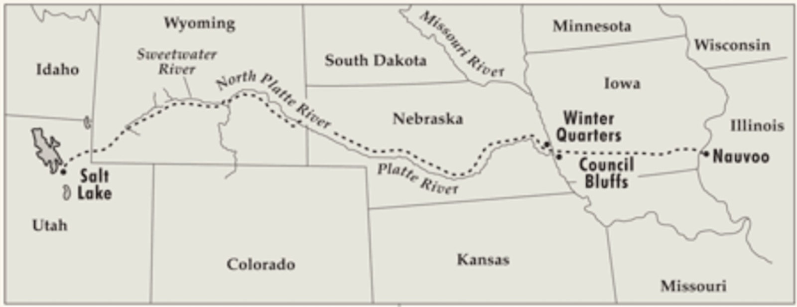
The Mormon Trail - 1846 to 1869 (courtesy of lds.org)


​This map shows the 1846 Momon presence along the Missouri River in what is now Omaha and Council Bluffs and their immediate surroundings. Today's highways and the Missouri River channel are superimposed.

The residential use of Winter Quarters was abandoned after one or two winters and Mormons who had not yet crossed relocated to camps across the river in Iowa.

Map by Robert Raymond, found at http://iagenweb.org/pottawattamie/map/map-RLDS-WinterQuarters-1846.htm, used with permission of the Winter Quarters Project.


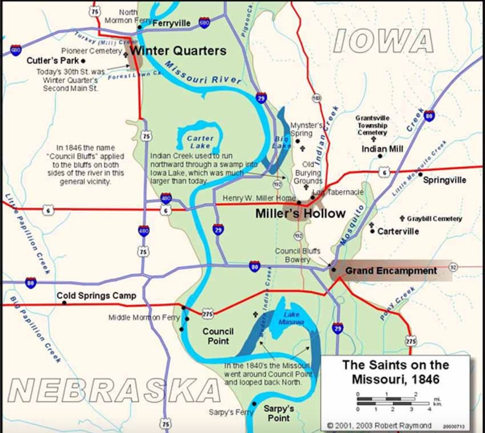
1846 LDS Presence in the Council Bluffs Area

This map shows the known Mormon camps in 1847-1853 in what became the western part of Pottawattamie County. Some observations:
  • Winter Quarters is the extreme left middle of the map.
  • Some camps spread out for several miles.
  • Although the maps of the Mormon camps along the Missouri are becoming more accurate, this map still has some errors. I noted that Benson's Mill should be shown along Pigeon Creek, and Bybee's Camp was south of Honey Creek along North Pigeon Creek. Cooley's Camp may also be mislocated.
  • The 1852-1853 Government Land Office survey maps of the area can help to locate camps.

Map found at ​http://winterquarters.byu.edu/Settlements
1847-53 LDS Presence in the Council Bluffs Area
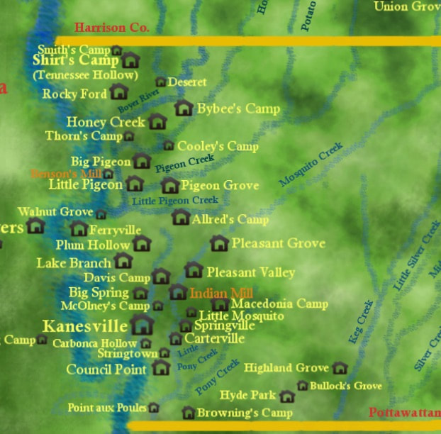
1847-1853 LDS Presence in the Council Bluffs Area
This index map locates Utah relative to neighboring states, as well as major Utah cities and some of the Utah towns most-significant in Mormon history.
  • Note the Sevier River in the southwest flowing northwards before making a giant loop and dead-ending in Sevier Lake.
  • Many of the Mormon families in my database settled in towns along or near the Sevier River.
The Green River flows south entering the Colorado Riber below Moab. The Colorado River flows southwesterly through Glen Canyon (now flooded), Marble Canyon, and the Grand Canyon.

Picture
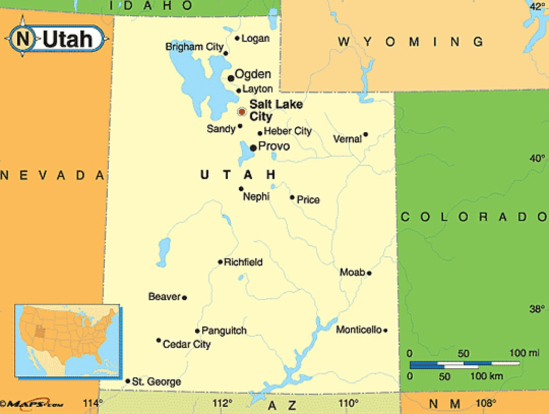
courtesy of maps.com

  • In this map, note Manti, Ephraim and Moroni in San Pete County, south of Provo. Numerous Danish Mormon immigrants settled in San Pete County.
  • Many of the 16 cousins discussed in Kirsten Pedersen's Relatives and related articles lived in or near these towns.
Utah Today Map
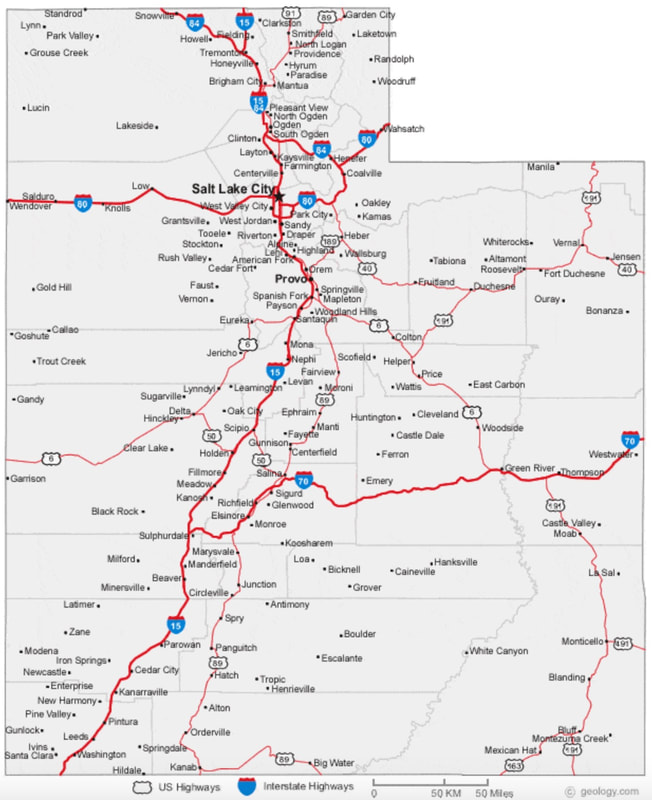
Utah Today (courtesy of geology.com)

Links to my Mormon History materials:
  • Gallery 1 - Mormon Maps (this webpage) - several maps related to the Mormon migration to Utah. 
  • Mormons in the Big Pigeon Area (report)- a collection of Mormon-related items. (21 pp., added 21 Dec '17).
  • Kirsten Pedersen (webpage) - Kirsten's second husband was John Erik Forsgren, a figure from early Mormon history; the family of Kirsten's daughter, Karen, were prominent in the Blair Branch of the Danish Lutheran church.
  • Kirsten's Descendants (webpage) - descendants of Kirsten Pedersen
  • Kirsten's Other Relatives (webpage) - selected nieces of Kirsten Pedersen
Proudly powered by Weebly