

bigpigeon.us webpage WWII-Japan > South & SW Pacific > Western New Guinea, © 2024 by Robert A. Christiansen, updated by RAC 24 Mar 2024.
Westward Along the North Coast of New Guinea - April to August 1944
Westward Along the North Coast of New Guinea - April to August 1944
|
By April 1944, General MacArthur's Southwest Pacific area forces - land, sea and air - were powerful enough and Japanese sea and air forces sufficiently weakened for major changes in Allied operations in New Guinea.
MacArthur's Sixth Army bypassed a large Japanese troop concentration in the Wewak area on the north coast of New Guinea and launched multiple operations in quick succession. During this period, Australian combat forces were released from participating in offensive operations and either returned to Australia to regroup and train or engaged in rear area mopping-up duties. |
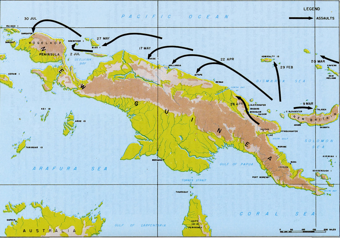
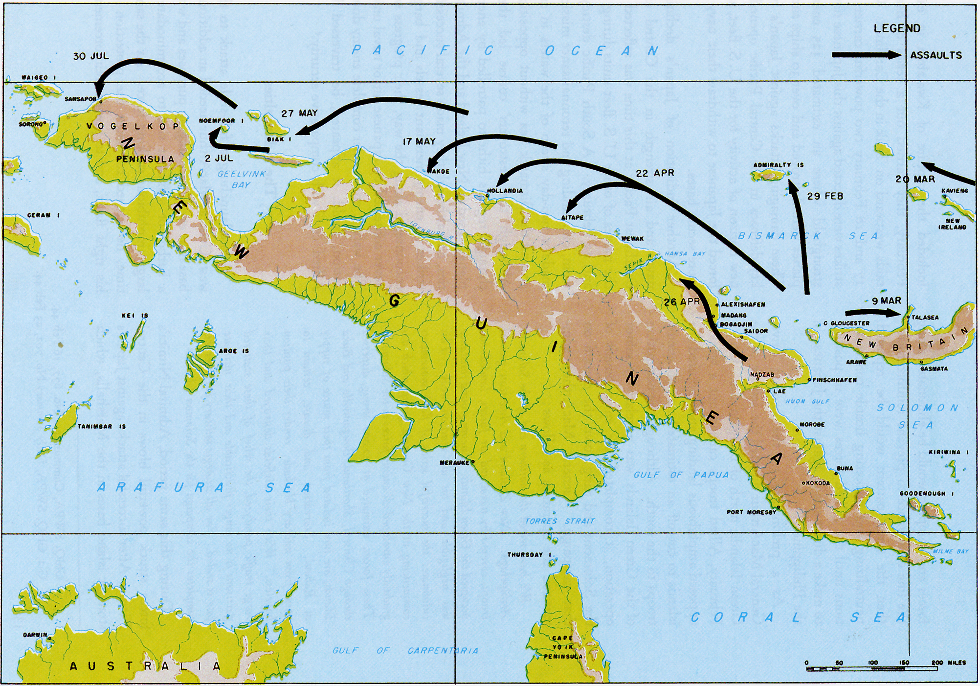
1944 New Guinea Offensives
|
Below I outline in chronological order the US operations in the Western New Guinea area. I believe only the Battle of Hollandia, the Battle of Lone Tree Hill, the Battle of Biak and the Battle of Driniumor River cost more than 100 American lives.
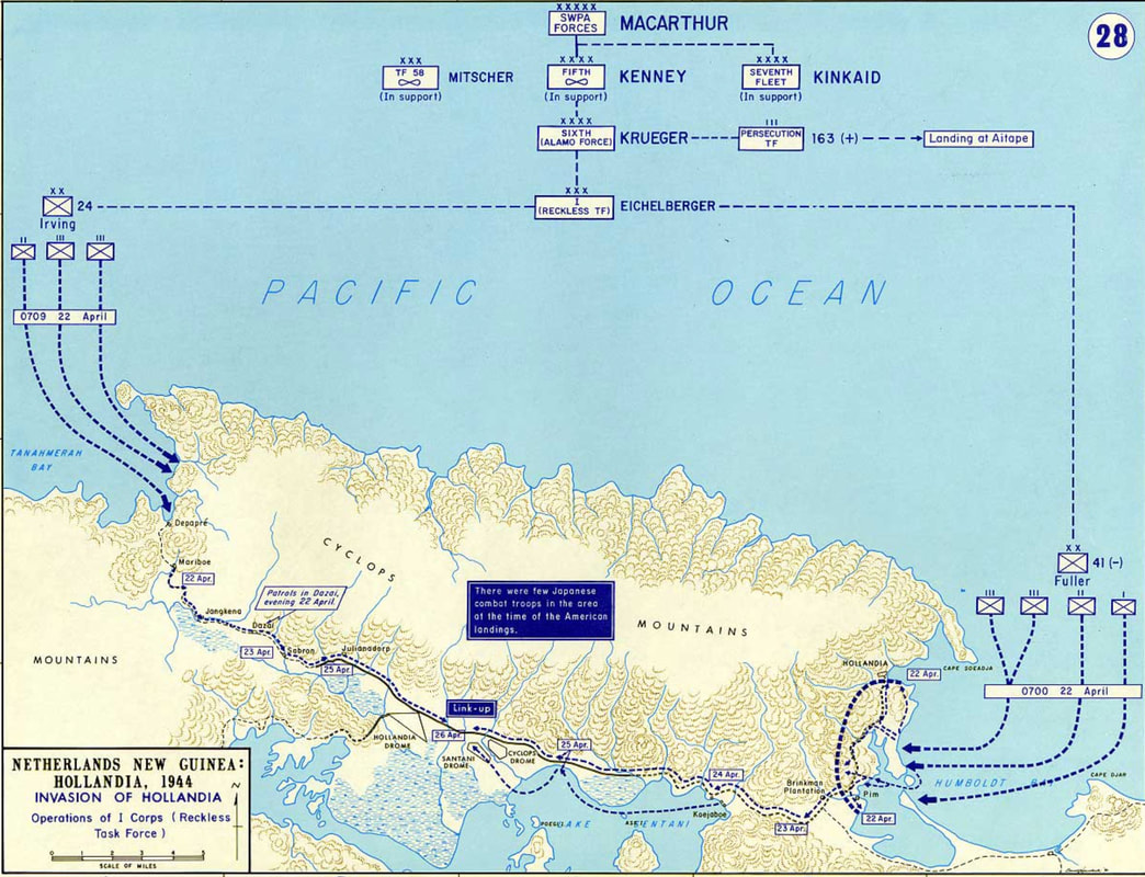
The Battle of Hollandia, 22-26 April 1944
|
Hollandia, now a city in Indonesia known as Jayapura, offered the best harbor for hundreds of miles along the north coast of New Guinea, as well as several airfields.
The large-scale Hollandia landings by the 24th and 41st Infantry Divisions were successful, but bypassed a concentration of Japanese troops in the Wewak area over 200 miles to the east. Around 157 US military died in the Battle of Hollandia. During the liberation of the Philippines, Hollandia served as a major rear-area base. |
The Battle of Hollandia
|
The Landing at Aitape, 22 Apr - 2 May 1944
|
Aitape is about halfway between Hollandia and Wewak.
To help protect Hollandia from the Japanese 18th Army to the east at Wewak, elements of the 41st Infantry Division landed at Aitape on 22 April, and soon secured the area. Aitape had the advantage of a nearby airfield. In mid-July, the 18th Army did attack, leading to the long Battle of the Driniumor River. The river is shown on the right of the accompanying map. |
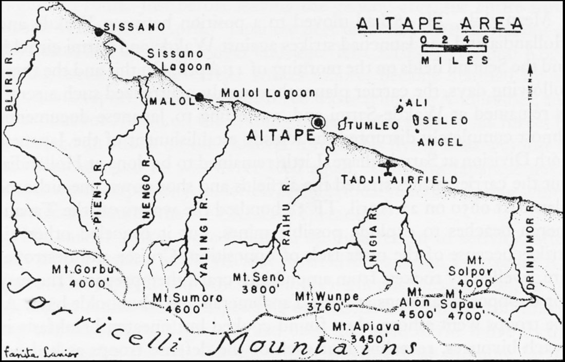
The Aitape Area
|
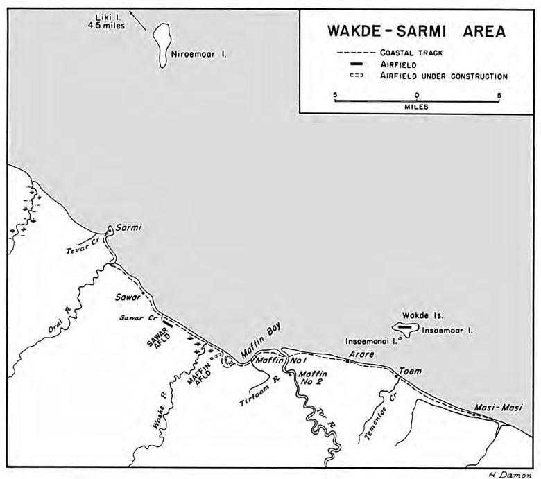
The Battle of Wadke, 17-21 May 1944 and The Battle of Lone Tree Hill, 17 May - 2 Sep 1944
The tiny Wadke Islands lie just off the New Guinea coast, 120 miles west of Hollandia. The US Sixth Army wanted to occupy the Wadke area in order to:
- Use the Wadke airfield to support pending operations further west in New Guinea.
- Use Maffin Bay, about ten miles west of Wadke, as a staging area for subsequent amphibious operations to the west.
|
Elements of the 41st Infantry Division landed on the New Guinea coast across from Wadke on 17 May. The following day Wadke was invaded, and after a four-day battle Wadke was secure. The Wadke airfield was quickly put in service. Around 40 US military died in the Battle of Wadke.
Japanese forces established a strong defensive line in the high ground east of the Woske River. The north anchor of this line was the so-called Lone Tree Hill, located between the beach and the coastal track. Not until the end of June was Lone Tree Hill secure, although Japanese forces remained on the west side of the Woske River. Over 400 US military died in the protracted Battle of Lone Tree Hill, which was arbitrarily declared over on 2 September 1944. |
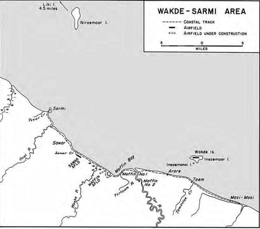
Maffin Bay Area Apr 1944
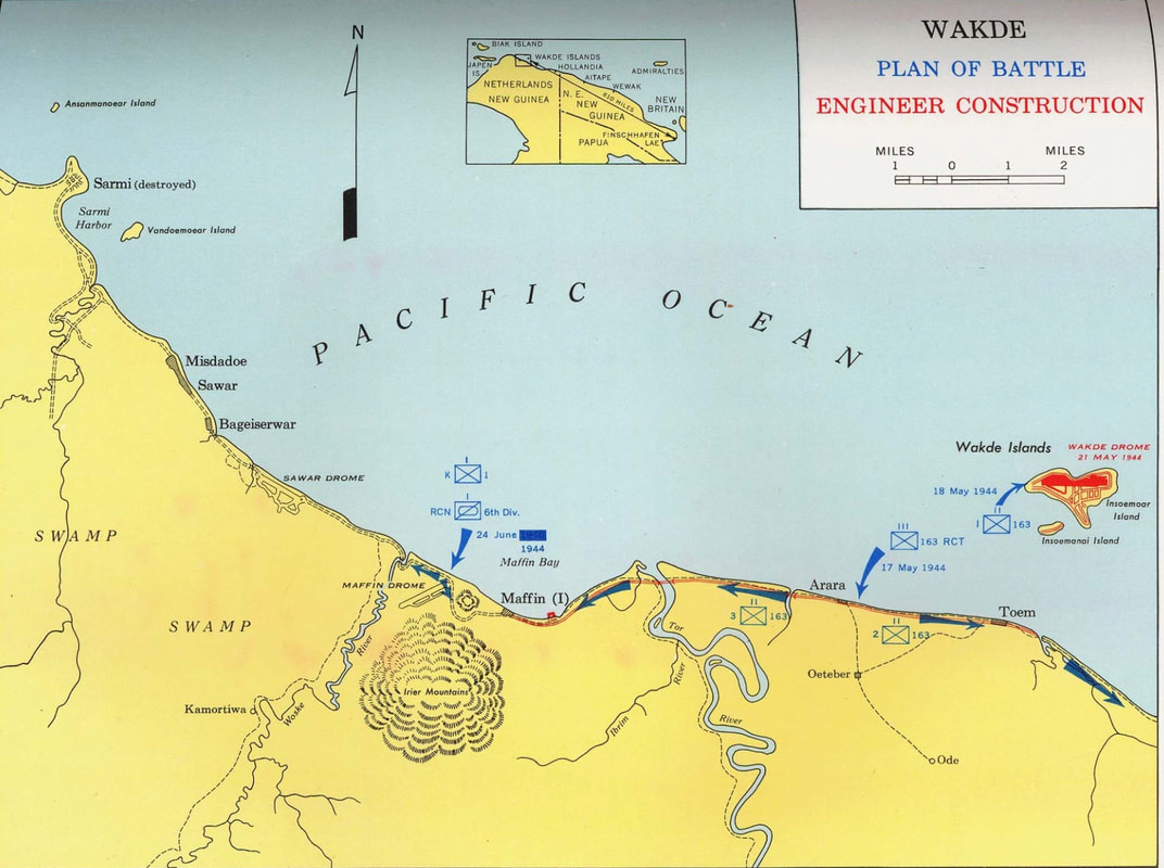
Wadke Islands and the Surrounding Area
|
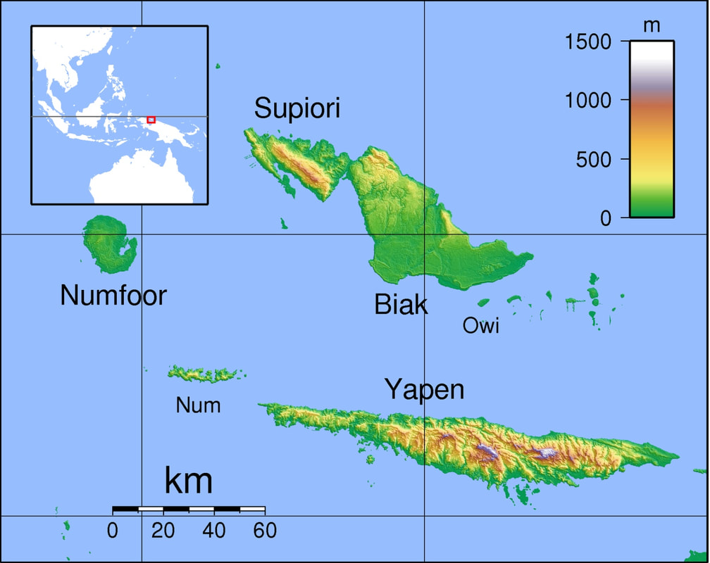
The Battle of Biak, 27 May - 20 Aug 1944
|
Because of the airfields on its south shore, the island of Biak was chosen for an amphibious landing by the reinforced 41st Infantry Division.
Unfortunately intelligence had underestimated the number of defenders. Moreover, cliffs containing fortified positions lay to the north of the airfields. The result was a long and difficult battle on a steaming jungle island, with 460 American dead, with isolated Japanese resistance continuing after the island was declared secured on 20 August. |
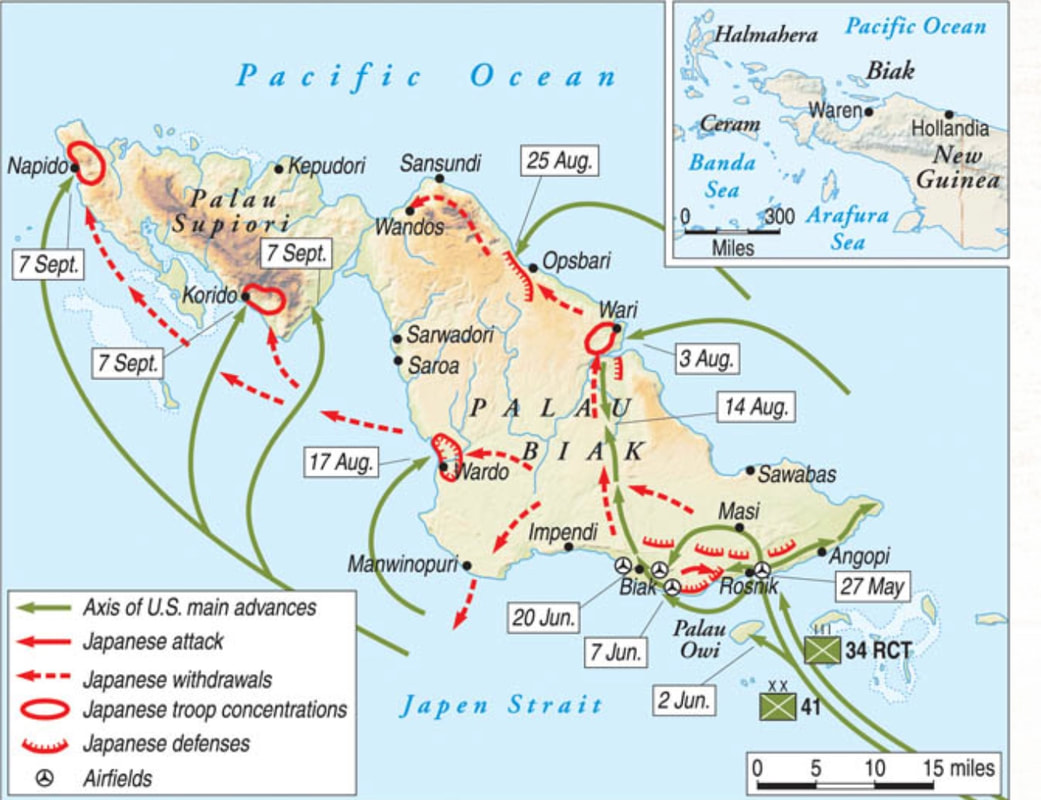
The Battle of Biak
|
The Battle of Noemfoor, 2 Jul - 31 Aug 1944
|
Because of the unexpected lack of progress early in the Battle of Biak, the Southwest Pacific Area command began planning a parallel invasion of Noemfoor Island to the west of Biak. Noemfoor also had several airstrips on the west and north shore, along with a much smaller Japanese garrison.
The first Allied aircraft began landing on Noemfoor on July 6. Noemfoor was secured on 7 July although isolated Japanese pockets remained in the interior and east. 66 Allied troops were killed on Noemfoor. |
Noemfoor & Biak
|
The Battle of the Driniumor River, 10 Jul - 25 Aug 1944
|
The Battle of Driniumor River was a defensive battle just east of Ataipe. The battle prevented the 18th Japanese Army troops, bypassed earlier in the Wewak area, from breaking through US lines.
The accompanying map shows positions at the beginning of the Battle of the Driniumor River. I have included this map because it shows the location of Troop F of the 112th Cavalry Regiment, which included my son-in-law's father, Lloyd Joyce. The Battle of Drinumor River left a much-weakened Japanese army in the Wewak area, at the cost of 440 Americans dead. |

|
The Vogelkop Peninsula
|
Elements of the 6th Infantry Division landed on the Vogelkop Peninsula at the western end of New Guinea on 30 July 1944. Over the next month, they encountered little opposition, losing only 14 dead.
On the adjoining map, note the bomber base at Mar, sometimes called Sansapor Airfield, and the fighter base on Middleburg Island. These were used by the Thirteenth Air Force to conduct raids over Celebes in the Netherlands Indies. |
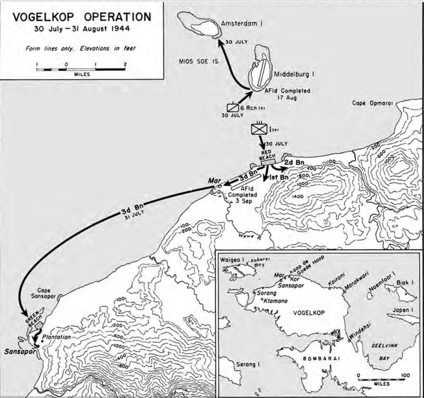
Operations near Sansapor on the Vogelkop Peninsula, Netherlands New Guinea
|
Morotai - 15 September 1944
|
The island of Morotai lies in today's Indonesia between the western tip of New Guinea and the south end of the Philippines island of Mindinao. Morotai appears in the upper right of the accompanying map.
When MacArthur's 31st Infantry Division invaded Morotai, Morotai was lightly defended, most area Japanese forces being on the nearby island of Halmahera. |
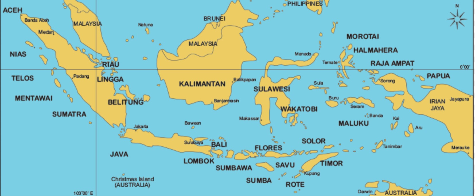
Indonesia, formerly the Dutch East Indies, as of 2018
|
Morotai was developed into a major air base, but a Japanese military presence on the island remained. PT boats interdicted nighttime Japanese barge traffic that brought supplies and reinforcements from Halmahera to Morotai.
When the War with Japan ended, 660 Japanese troops remained on Morotai, and 40,000 on Halmahera.
When the War with Japan ended, 660 Japanese troops remained on Morotai, and 40,000 on Halmahera.
A family note: Both my late father-in-law, Albert Dennis, and my daughter's father-in-law, Lloyd Joyce, participated in the Western New Guinea campaign.
- Albert Dennis was a crew member of the PT Tender Oyster Bay, which escorted PT boats to Morotai for the use noted above before escorting another PT squadron to Leyte Gulf.
- Lloyd Joyce served in Troop F of the 112th Cavalry Regiment, which fought at the Battle of the Driniumor River. Then he, although sick with malaria, moved on to Leyte with his regiment.
Sources for Big Pigeon's South & SW Pacific > Western New Guinea webpage:
Pottawattamie County, Iowa area WWII Dead - South & SW Pacific > Western New Guinea:
† Christensen, Dale Eldon, SN O-2-036049, US Army, Audubon Co.
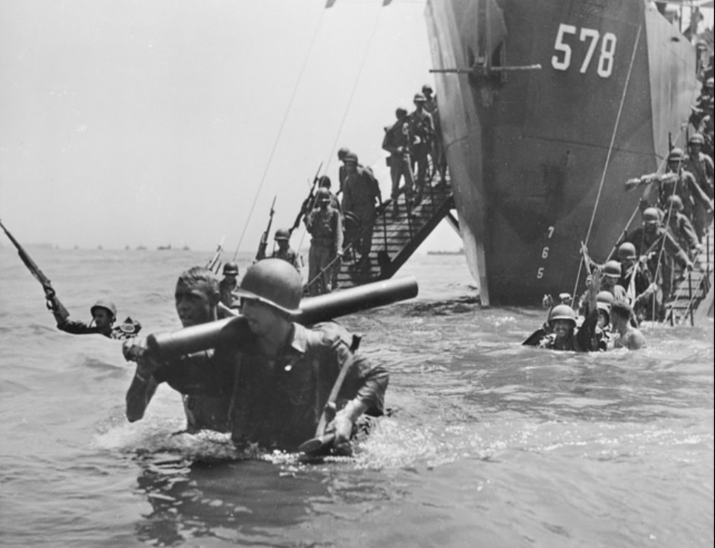
- The photo Wet Landing at Morotai is courtesy of wikipedia.org.
- The 1944 New Guinea US Offensives map - https://history.army.mil/books/wwii/MacArthur%20Reports/MacArthur%20V1/Images/p_039.jpg.
- The Battle of Hollandia map is part of the United States Military Academy on-line map collection at https://www.westpoint.edu/academics/academic-departments/history/atlases, and is also available at http://www.emersonkent.com/maps.htm.
- The Aitape Area map - https://www.ibiblio.org/hyperwar/AAF/IV/maps/AAF-IV-28.jpg.
- The Wadke Islands and the Surrounding Area map - https://en.wikipedia.org/wiki/Battle_of_Wakde#/media/File:Wakde_battle_plan_1947.jpg.
- The Maffin Bay Area, April 1944 map - http://tothosewhoserved.org/usa/pto/usapto08/img/img207.jpg.
- The Battle of Biak map is taken from warfarehistorynetwork.com/2018/12/30/the-battle-of-biak-a-terrifying-glimpse-into-the-soul-of-mankind.
- The Driniumor Line map - https://www.ibiblio.org/hyperwar/USA/USA-P-Approach/maps/USA-P-Approach-7.jpg.
- The Operations near Sansapor map - https://en.wikipedia.org/wiki/Battle_of_Sansapor#/media/File:Operation_Typhoon.png
- The Westward Drive Along New Guinea, Chapter 6 of The Campaigns of MacArthur in the Pacific - https://history.army.mil/books/wwii/macarthur%20reports/macarthur%20v1/ch06.htm.
Pottawattamie County, Iowa area WWII Dead - South & SW Pacific > Western New Guinea:
- Taken from the bigpigeon.us WWII Dead module.
† Christensen, Dale Eldon, SN O-2-036049, US Army, Audubon Co.
- Troop E, 112th Cavalry Regt.; KIA 4 Aug 1944 near Afua, New Guinea; Battle of the Driniumor River - South & SW Pacific > Western New Guinea.
- Destroyer USS Kalk (DD-611), Seventh Fleet; KIA 12 Jun 1944 off southern coast of Biak Is., W. of Hollandia, Dutch New Guinea; Kalk hit by Japanese bomb while escorting LSTs from Hollandia, New Guinea to Biak; thirty dead, 40 wounded, Kalk survived; South & SW Pacific > Western New Guinea; BNR.
- 836th Engineering Aviation Bn.; KIA 19 May 1944 Wadke Is., W of Hollandia, Dutch New Guinea; Battle of Wadke - South & SW Pacific > Western New Guinea.