

bigpigeon.us webpage Home > Resources > Land Records, updated by RAC 16 Apr 2021.
This is a sister webpage to Pott. Co. > Big Pigeon Area > Maps & Plats, which focuses on early land ownership in the Big Pigeon area.
This is a sister webpage to Pott. Co. > Big Pigeon Area > Maps & Plats, which focuses on early land ownership in the Big Pigeon area.
|
Overview of Public Land Distribution
The green part of the accompanying map shows what are known as the public land survey states (PLSS). The United States acquired title to the majority of this land by treaties of cession with Native American tribes. After the United States had acquired title, blocks of PLSS land was surveyed by the General Land Office (GLO), the precursor of today's Bureau of Land Management (BLM). Once surveyed, parcels therein could be conveyed to individuals or to other jurisdictions, who then held title to such land. |
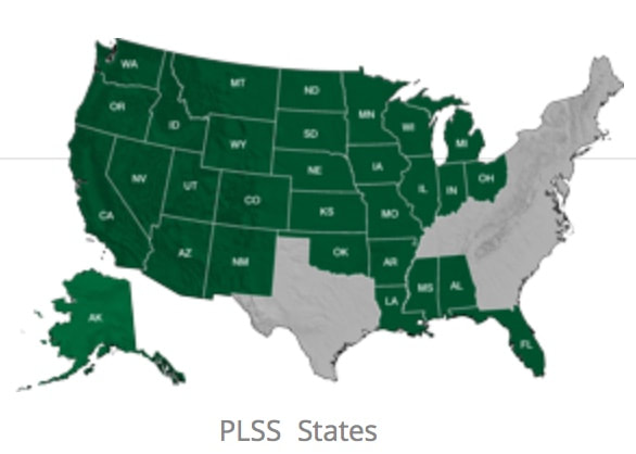
The Public Land Survey States
|
|
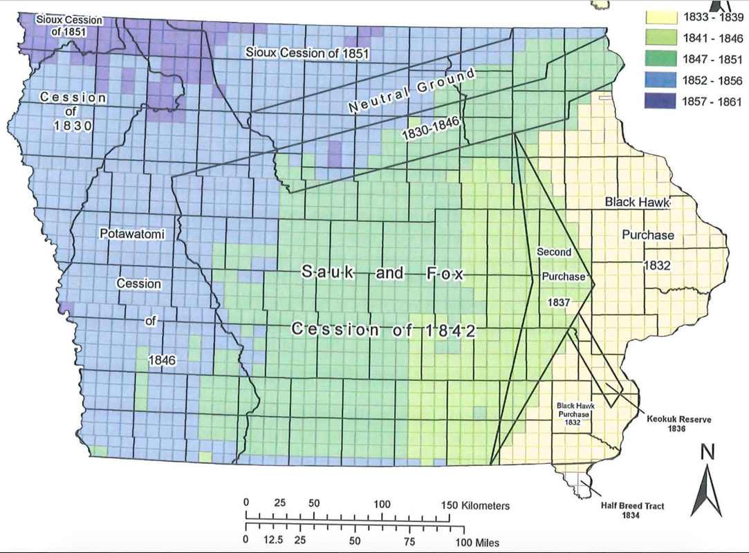
Survey Townships
In order to identify a parcel of PLSS land, the GLO surveys divided land into a grid of survey townships, also known as congressional townships. Each survey township was in theory a square six miles in dimension, thus consisting of 36 square miles. The acccompanying map shows the grid of survey townships in Iowa. Superimposed are the different Native American land cessions and today's county boundaries, with survey dates color coded. The earth's curvature, geographic obstacles, and survey errors meant that survey townships were not exactly of the desired size. Meridians and Baselines
Surveying public lands in the United States was a complex, multi-step process extending over many years. Public lands were broken up into survey areas, each using a north-south meridian and an east-west baseline. As the accompanying map shows, Iowa was among the midwestern states surveyed in reference to the 5th principal meridian, which runs through extreme eastern Iowa and uses a baseline in Arkansas. As illustrated below, within a survey area two numbers, township and range, identified a survey township in reference to the area's baseline and meridian. |
Iowa's Survey Townships
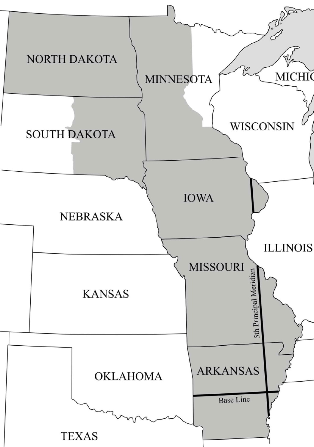
5th Principal Meridan Survey Area
|
|
Township Identification, Section Numbering, and Section Subdivision
|
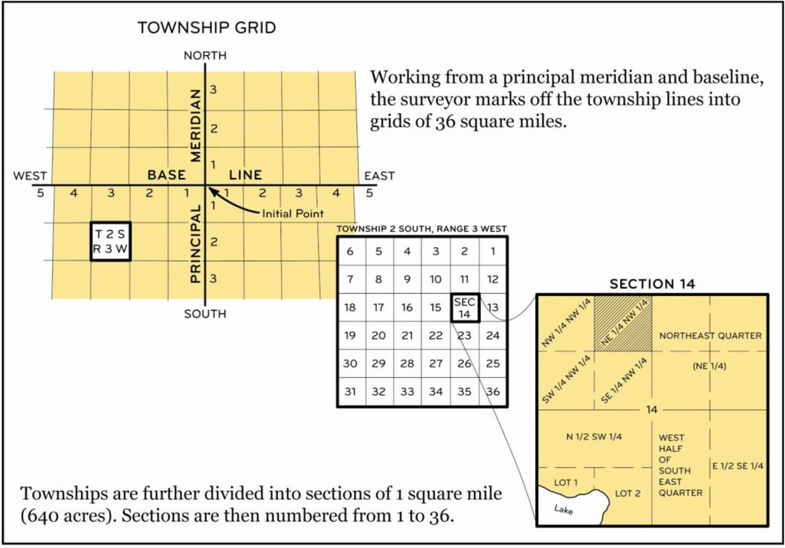
Township Grid, Section Numbering, and Section Subdivision
|
|
Survey Maps
GLO township surveyors produced a map for each survey township. These maps were then sent to the GLO main office, which for Pottawattamie County was far away in Dubuque. Microfilms of most Iowa survey maps exist. The accompanying map is the survey township map of a portion of northern Decatur County in northeastern Iowa. |
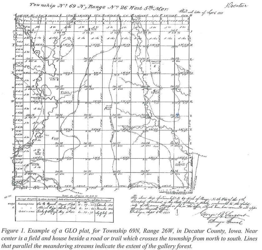
Sample Survey Map
|
|
GLO Land Offices
After a block of land was surveyed and the surveys were processed, the GLO then offered most of the land therein to the public through an area land office. Conveyance to an individual might happen in several ways, including:
|
Known Iowa land offices and their dates:
|
|
Land Patents
After acquiring land at an area land office, the owner would eventually receive a certificate of ownership, called a land patent, from the GLO headquarters in Washington. Due to the large number of land purchases and the time required for correspondence between Washington and the field, months, sometimes a few years, would elapse between purchase and receipt of a land patent. |
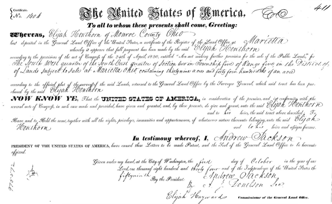
Sample Land Patent
|
|
County Records
In Pottawattamie County, one can find land records in both the Recorder's office and the Auditor's office. I have found most-useful for my research the township books in the Auditor's office. Each section has one or more pages in a book for that township. Know the township and section and years of interest before beginning. |
The complete set of papers for a real estate title, known as the abstract of title, can be very lengthy, as it includes not only purchase and sale information since the original land office entry, but mortgage and property tax lien information.
Specialized abstract companies provide the link between the real estate industry and the county Court House records. |
|
Township Plats
A township plat is a map that shows land ownership of a particular township at a given time.
The accompanying plat illustrates what a typical township plat looks like. Note that this plat is not fully readable. A township plat is too complex to be viewed in its entirety on a single computer screen. The Iowa township survey maps and township plats accessible from digital.lib.uiowa.edu were scanned at a high resolution and include controls that allow selecting and enlarging a township portion for viewing. |

1900 Plat for Boomer Township - T77N,R43W
|
Websites:
Sources for the Resources Overview - Land Records webpage:
- 1851-1852 Pottawattamie County land survey maps - https://digital.lib.uiowa.edu/islandora/search/pottawattamie?type=edismax&cp=ui%3Aglo
- Original entry land records - https://glorecords.blm.gov/search/default.aspx
- Township plats in Pottawattamie County atlases - https://digital.lib.uiowa.edu/islandora/search/pottawattamie?type=edismax&cp=ui%3Aatlases.
- Before using these websites to view a township, know the township and range number.
- For original entry records, you will also need the section number.
- Most land in the Big Pigeon area was bought by speculators in the 1850s and wasn’t put into use by a farmer until after some years after the Civil War ended.
- The files accessed from the above links are several megabytes in size and might load slowly on your computer.
- The GLO township survey maps are dfficult to interpret and not helpful for genealogists.
- Printed Pottawattamie County plats for various years are available at the Pottawattamie County Genealogical Society and the Council Bluffs Public Library.
- One can acquire recent county platbooks. However, unless you have a farmer friend with an extra copy, they are expensive.
Sources for the Resources Overview - Land Records webpage:
- The Public Lands Survey States map, courtesy of Digital Data Systems Inc. - http://www.plssdata.com/index.php?option=com_content&view=article&id=472&Itemid=857.
- The Iowa's Survey Townships map and the Sample Survey Map, pages 2 and 4 of http://publications.iowa.gov/29828/1/EnhancedAccesstoIowasGeneralLandOffice.pdf, a 24-page 2008 publication of the Iowa Office of the State Archeologist.
- The 5th Principal Meridian Survey Area map, courtesy of The American Surveyor - https://archive.amerisurv.com/PDF/TheAmericanSurveyor_Elgin-5thPrincipalMeridianIntialPoint_April2015.pdf.
- The Township Grid, Section Numbering, and Section Subdivision diagram, courtesy of the Bureau of Land Management - https://www.blm.gov/sites/blm.gov/files/uploads/IB2013-057_att1.pdf.
- Data for the Iowa Land Offices and Their Dates list is taken from https://www.archives.gov/research/guide-fed-records/groups/049.html#49.9.11, which includes a summary of paper holdings at the National Archives Kansas City facility. I am not sure that this is a complete list of Iowa land offices.
- The Sample Land Patent is courtesty of https://en.wikipedia.org/wiki/Land_patent.
- The 1900 Boomer Township Plat is courtesy of iagenweb.org/pottawattamie.