

bigpigeon.us webpage WWII Germany > The ETO > Normandy Campaign > D-Day, © 2023 by Robert A. Christiansen, updated by RAC 26 Sep 2022.
European Theater ground operations began on 6 June 1944 when Allied forces invaded France by crossing the English Channel from England to Normandy, landing on five beaches between Cherbourg and Le Havre.
European Theater ground operations began on 6 June 1944 when Allied forces invaded France by crossing the English Channel from England to Normandy, landing on five beaches between Cherbourg and Le Havre.
D-Day, the Normandy Landings, Context
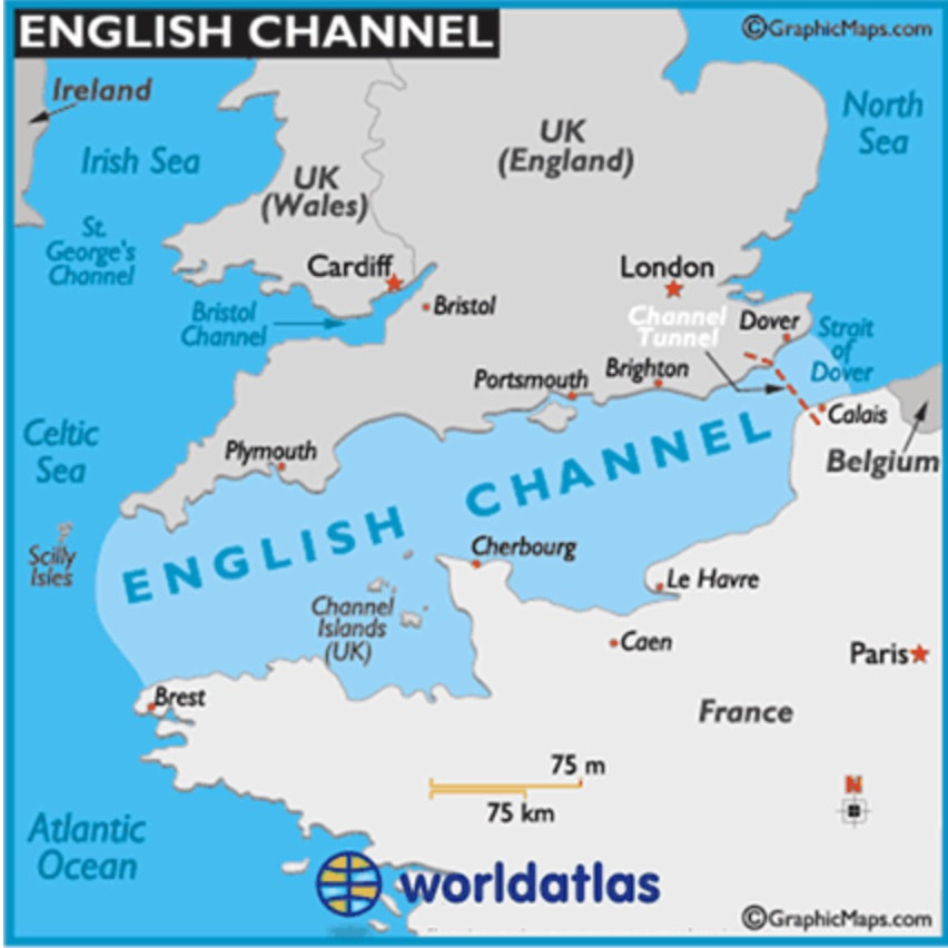
The English Channel Area
|
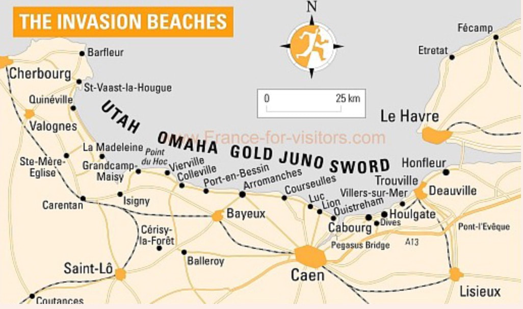
The Five Invasion Beaches
|
Utah Beach Airborne Support
|
The German army expected an Allied cross-channel invasion somewhere during the spring of 1944, most likely further north near Calais at the Straits of Dover, which separate the English Channel and the North Sea.
Overall commander for D-Day and subsequent operations was US General Dwight Eisenhower, heading an Allied organization called Supreme Headquarters, Allied Expeditionary Forces, or SHAEF. Operation Overlord was the code name used for the Normandy invasion, with Operation Neptune being the naval component.
ETO staff were confident the invasion would succeed.
The invasion was originally scheduled for June 5, but was postponed for one day because of a storm. The weather remained so unsettled that many German generals, including the German commander, Ervin Rommel, had assumed the invasion would be postponed. Thus, Rommel and many other senior officers had left their posts in Normandy.
The Operation Overlord ground forces totaled around 2,000,000, with 156,000 landing by sea and air on D-Day. D-Day landing forces consisted primarily of American, British and Canadian troops who had trained for months in England preparing for the invasion. Thousands of aircraft and around 3,500 ships and boats from many nations provided support.
The five invasion beaches extended over about 50 miles of Normandy coast. These were sandy beaches, separated from each other by rocky areas. As shown on the above map, each beach had a code name.
Overall commander for D-Day and subsequent operations was US General Dwight Eisenhower, heading an Allied organization called Supreme Headquarters, Allied Expeditionary Forces, or SHAEF. Operation Overlord was the code name used for the Normandy invasion, with Operation Neptune being the naval component.
ETO staff were confident the invasion would succeed.
- The Allies controlled both air and sea and possessed a huge, well-supplied army.
- Germany, however, had manpower issues because of the large and ongoing casualties in the war against Soviet Union on the Eastern Front. The German troops in the beach area were fewer than required and many were non-Germans who had been pressed into military service.
- Some German fortifications were incomplete and some artillery had not arrived.
The invasion was originally scheduled for June 5, but was postponed for one day because of a storm. The weather remained so unsettled that many German generals, including the German commander, Ervin Rommel, had assumed the invasion would be postponed. Thus, Rommel and many other senior officers had left their posts in Normandy.
The Operation Overlord ground forces totaled around 2,000,000, with 156,000 landing by sea and air on D-Day. D-Day landing forces consisted primarily of American, British and Canadian troops who had trained for months in England preparing for the invasion. Thousands of aircraft and around 3,500 ships and boats from many nations provided support.
The five invasion beaches extended over about 50 miles of Normandy coast. These were sandy beaches, separated from each other by rocky areas. As shown on the above map, each beach had a code name.
- The United States Army landed on the two western beaches, Utah and Omaha, about ten miles apart.
- The British and Canadians on the three eastern beaches, Gold, Juno and Sword.
- The small port town of Port-en-Bessin marked the boundary between American and British forces.
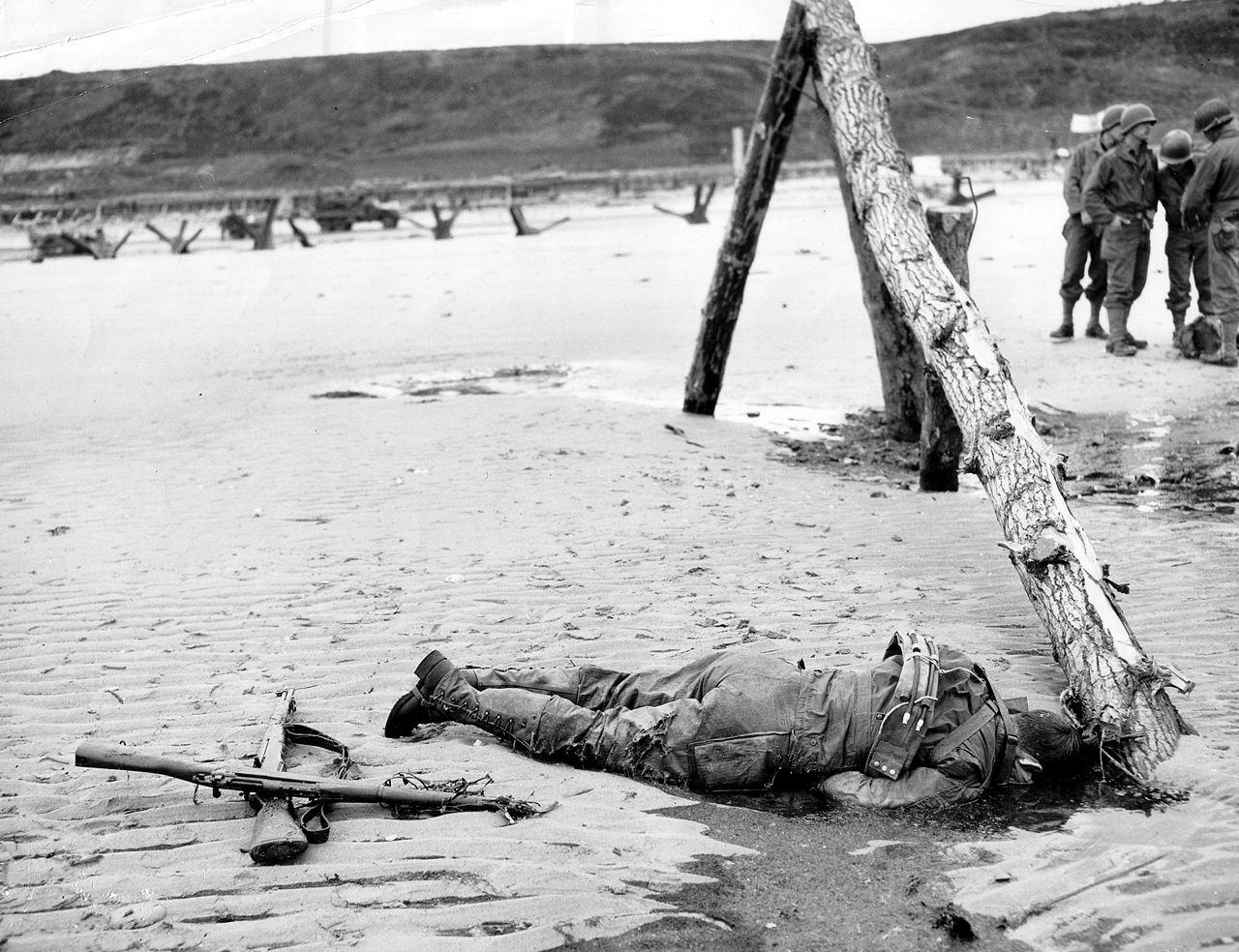
Germany had strewn potential invasion beaches with physical obstacles, thus necessitating a landing at low tide. Behind the beaches were prepared and hardened German positions, sometimes including large artillery pieces. A heavily-burdened infantryman coming off a landing craft could expect a long trudge up the beach, initially through water, in the face of enemy fire.
The US Sector, Utah and Omaha Beaches
Utah and Omaha beaches, although both long and sandy, differed in one major aspect, namely what was behind the beach:
The First Twelve Hours:
Shortly after midnight, the three Allied airborne divisions began landing by parachute and by glider, the US 82nd and 101st Airborne Division behind Utah Beach and the British 6th Airborne Division nearly fifty miles to the east, on the extreme east end of the invasion area, near the Pegasus Bridge shown on a previous map. The Brits seized the Pegasus Bridge and nearby areas, thus preventing German reinforcements from reaching the invasion area via coastal roads.
At low tide after daybreak around 6:30 a.m., the main D-Day force began landing on the five Normandy beaches. In the US sectors, the 29th Infantry Division landed on Utah Beach and the 29th and 1st Infantry Divisions on Omaha Beach. They came ashore in separate waves on landing craft, specialized boats with drop-down ramps on the front. After the landing craft hit the sand, the men struggled to make their way through shallow water and off the beach. Because of the wind and waves, tides and poor visibility, and general confusion, the initial waves generally landed in the wrong location.
In addition to the airborne landings and the five beach landings, several hundred members of the US 2nd Ranger Battalion landed at the base of the Point de Hoc cliff and fought their way up to the crest with the mission of destroying four heavy artillery pieces.
Utah Beach:
In actuality, our airborne troops landed behind Utah Beach in scattered locations and thus initially lacked unit cohesion. Many were injured while landing or were killed by the Germans as they landed. Gradually ad-hoc groups of survivors formed and the airborne divisions secured the causeway exits and reached some of their other goals.
The 4th Infantry Division of VII Corps landed on Utah Beach starting at 6:30 am. Caught by currents, the landing craft dropped the first waves in the wrong location. The first commanding officer on Utah Beach, Theodore Roosevelt Jr., took decisive control and with low losses the division began to move inland over the causeways.
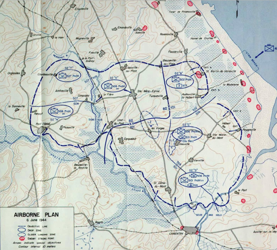
- Behind Utah Beach is a low area, which in 1944 the Germans had flooded. Several causeways through the flooded area led to higher land to the west containing two market towns, Sainte Mere Eglise and Sainte Marie du Mont.
- ETO planned a night paratroop drop on this higher land to seize the causeways and other critical positions, thus facilitating movement inland of the seaborne Utah Beach invasion force. The third map above shows where the six regiments of the two American airborne divisions, the 82nd and the 101st, meant to land behind Utah Beach, which is in the upper-right corner.
- Behind the six miles of Omaha Beach is an eroded bluff about 100 feet high, visible through the fog of battle in a following photo. Behind the bluff face is a plateau region with many villages and farms, the farms specializing in dairy operations. Several road and some pathways follow draws in the bluff from the plateau to the beach area; see the second map below.
- Today, as in 1944, the west end of Omaha beach is more heavily developed, with a seawall, a road parallel to the beach, and buildings between the seawall and the bluff.
- Today the eastern part of Omaha Beach lacks both a road along the beach and structures. Between the sandy beach and the bluff is a sandy, shrubby area.
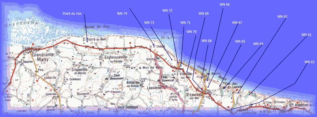
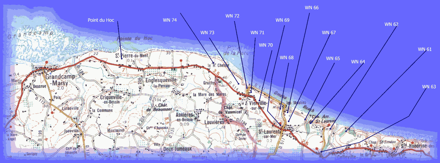
- By June 1944, Germany had built positions called Widerstandeneste (resistance nests) on the bluff face. A typical position included a concrete bunker containing artillery, with connecting trenches and machine gun and mortar positions. Germany artillery observers could also use these positions to call in fire from additional guns hidden on the plateau behind the bluffs. The first map below shows Widerstandeneste locations.
- Because of the fortified bluff face, planners had decided to land two divisions on Omaha Beach on D-Day.
The First Twelve Hours:
Shortly after midnight, the three Allied airborne divisions began landing by parachute and by glider, the US 82nd and 101st Airborne Division behind Utah Beach and the British 6th Airborne Division nearly fifty miles to the east, on the extreme east end of the invasion area, near the Pegasus Bridge shown on a previous map. The Brits seized the Pegasus Bridge and nearby areas, thus preventing German reinforcements from reaching the invasion area via coastal roads.
At low tide after daybreak around 6:30 a.m., the main D-Day force began landing on the five Normandy beaches. In the US sectors, the 29th Infantry Division landed on Utah Beach and the 29th and 1st Infantry Divisions on Omaha Beach. They came ashore in separate waves on landing craft, specialized boats with drop-down ramps on the front. After the landing craft hit the sand, the men struggled to make their way through shallow water and off the beach. Because of the wind and waves, tides and poor visibility, and general confusion, the initial waves generally landed in the wrong location.
In addition to the airborne landings and the five beach landings, several hundred members of the US 2nd Ranger Battalion landed at the base of the Point de Hoc cliff and fought their way up to the crest with the mission of destroying four heavy artillery pieces.
Utah Beach:
In actuality, our airborne troops landed behind Utah Beach in scattered locations and thus initially lacked unit cohesion. Many were injured while landing or were killed by the Germans as they landed. Gradually ad-hoc groups of survivors formed and the airborne divisions secured the causeway exits and reached some of their other goals.
The 4th Infantry Division of VII Corps landed on Utah Beach starting at 6:30 am. Caught by currents, the landing craft dropped the first waves in the wrong location. The first commanding officer on Utah Beach, Theodore Roosevelt Jr., took decisive control and with low losses the division began to move inland over the causeways.
Omaha Beach
Omaha Beach Area Road Map, with Widerstandeneste positions marked
|
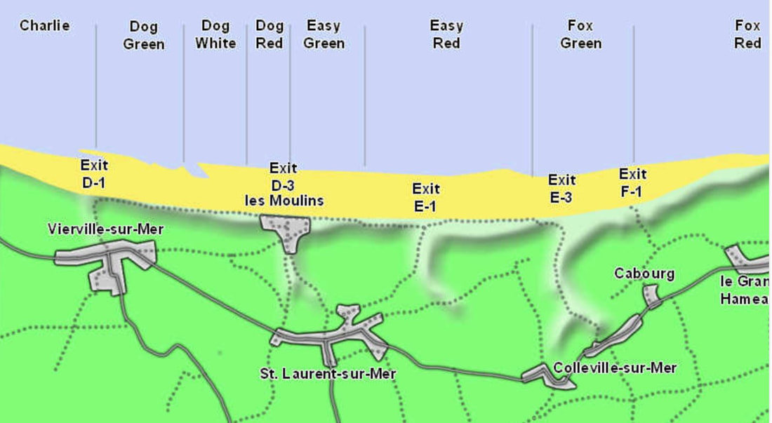
Omaha Beach Area, with landing beaches and beach exits marked
|
|
The First Waves:
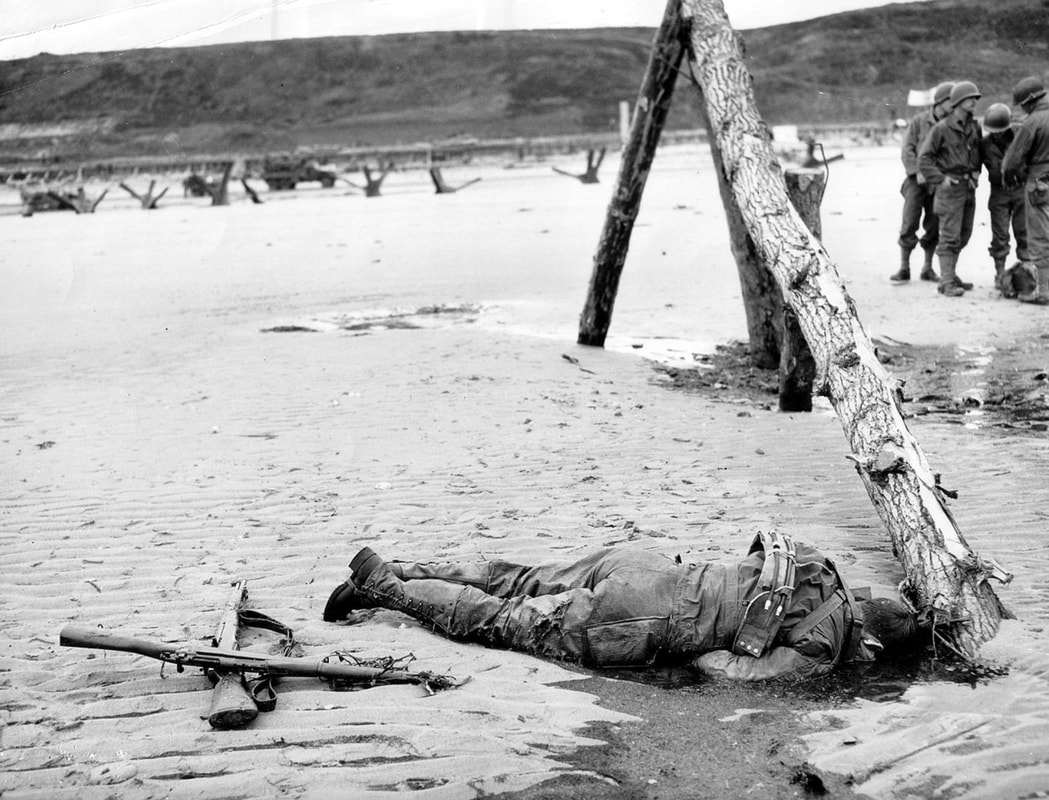
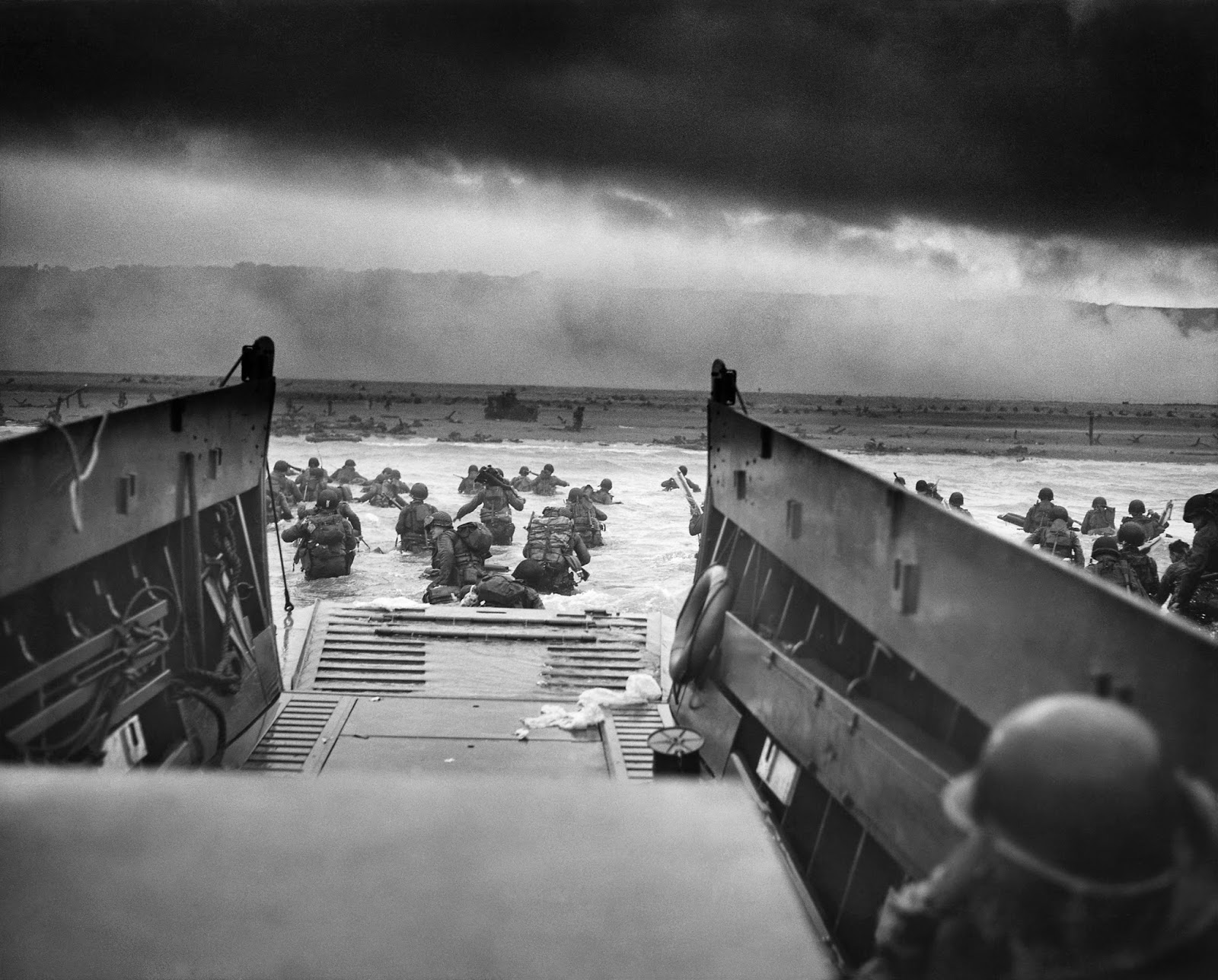
Unlike the other four beach landings, the Omaha Beach landing initially faltered. At one time during the morning, General Omar Bradley, the senior American commander who was on a nearby ship, considered withdrawing his troops from Omaha. Besides the Widerstandeneste, the upper part of the bluff contained several areas where German infantry was stationed. From their positions on the bluff, the Germans fired on our soldiers as they left their landing craft, struggled to the beach, and then tried to cross the obstacle-laden beach and climb the bluffs, all the time carrying their heavy gear. |
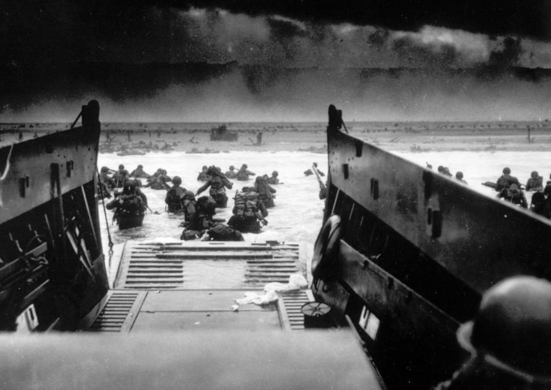
Omaha Beach Landing, A LCVP (Landing Craft, Vehicle, Personnel) from the U.S. Coast Guard-manned USS Samuel Chase disembarks troops of Company E, 16th Infantry, 1st Infantry Division (the Big Red One) wading onto the Fox Green section of Omaha Beach (Calvados, Basse-Normandie, France) on the morning of June 6, 1944. American soldiers encountered the newly formed German 352nd Division when landing. During the initial landing two-thirds of the Company E became casualties. Artist: Chief Photographer's Mate (CPHoM) Robert F. Sargent.
|
What went wrong at Omaha Beach:
What went right at Omaha Beach:
By noon of D-Day, small American units had reached the plateau behind the bluff.
Some Omaha Beach Details:
Each of the two V Corps divisions that landed on Omaha beach on D-Day had an assault regiment, which comprised the first waves of the invasion.
On 6 June, by the end of D-Day, the German positions on the bluff overlooking Omaha Beach had been taken and the American survivors from Omaha Beach had moved to the plateau behind the bluff. The battle for Omaha Beach was over.
- Miscalculation of enemy strength: Unknown to Allied intelligence, the Germans had moved another division into the invasion area shortly before D-Day.
- Bombardment failure: During the night, Allied aircraft had dropped bombs on the Omaha Beach area, and later warships had shelled the area. However, the naval shelling was inadequate and the aerial bombs didn't land on the German positions on the bluff face, but rather in scattered areas on the plateau behind the bluff. The bombs killed more cows than German soldiers.
- Lack of onshore armor: 32 tanks in the 741st Tank Battalion had been converted to improvised amphibious tanks to provide early land-based fire support for first Division infantry. Due to heavy seas from the previous storm, 27 of these tanks were swamped before reaching land.
- Just wondering: By June 1944, US Marines in the Pacific were no longer storming beaches without truly amphibious vehicles such as DUKWs and AmTracs. Why were these not used on Omaha Beach?
What went right at Omaha Beach:
- No German reinforcements: The German positions on the bluff face received little, if any, supply or additional troops during the day. The German high command response to the invasion was slow, and the heavy incoming fire in the bluff area may have discouraged local commanders from sending in reinforcements. As positions were taken out of action or ran out of ammunition, resistance tapered off.
- Naval assistance: Multiple American destroyers risked running aground by coming in close and firing directly at targets of opportunity on the bluff face.
- Gaps in German fields of fire. Omaha Beach was six miles long and the bluff face is quite irregular. Gradually our forces found areas to ascend that lacked intense German covering fire.
- Courage and common sense. Caught with little cover on the beach, many men concluded that it was safer to attempt to move upward onto the bluff rather than remain exposed on the beach.
By noon of D-Day, small American units had reached the plateau behind the bluff.
Some Omaha Beach Details:
Each of the two V Corps divisions that landed on Omaha beach on D-Day had an assault regiment, which comprised the first waves of the invasion.
- To the west: the 116th Infantry Regiment of the 29th Infantry Division. This regiment was originally composed of National Guard troops from Maryland and Virginia. The Bedford Boys, nineteen men from the small town of Bedford, Virginia died that day on Omaha Beach.
- To the east: The 16th Infantry Regiment of the 1st Infantry Division. When Martha and I moved to Williamsburg, Virginia in 1997, we met Bette Mae Schintzel who brought us freshly-baked rolls. I was privileged to later know her husband, Arthur Schintzel, an Omaha Beach survivor of the 16th Infantry. Art, who was 22 years old at the time, was in Company B, which landed in the second wave about 7 a.m. Art was shot four times while trying to climb the bluff behind the beach. While he was waiting on a landing craft to be evacuated back to England, Art received two more shrapnel wounds. Art received two Purple Hearts and spent the rest of World War II in hospitals.
On 6 June, by the end of D-Day, the German positions on the bluff overlooking Omaha Beach had been taken and the American survivors from Omaha Beach had moved to the plateau behind the bluff. The battle for Omaha Beach was over.
D-Day Summary
Like the 4th Infantry Division on Utah Beach, the British and Canadian landings on Gold, Juno and Sword beaches also went well. Casualties (killed, missing, prisoner, and wounded) were lower than expected but not all the objectives for the day were reached. The Omaha Beach landing by the 29th and 1st Infantry Divisions was a different story, as summarized above.
By the end of D-Day, fewer than 10% of personnel in the allied armies had landed in Normandy. The rest of the invasion army was brought across the English Channel in the following days, weeks and months.
Surprisingly, military experts disagree widely on the estimated number of Allied casualties on D-Day. The total was underreported for many years and is now estimated at around 11,000. I'm inclined to think there were about 12,000 Allied casualties, of which around 4,500 were killed. The Allied D-Day deaths would be about the same number of US deaths during the long war with Iraq.
The longer, larger and much bloodier Normandy Campaign was just beginning. Combat in the Normandy area would continue into mid-August.
Sources for Big Pigeon's The ETO > Normandy Campaign > D-Day webpage:
General sources:
Pottawattamie Area WWII Dead - The ETO > Normandy Campaign > D-Day:
General sources:
- Normandy: 6 June--24 July 1944, by William M. Hammond, 47 pp. [CMH #72-18] - four maps, one scalable.
- Cross-Channel Attack, by Gordon A. Harrison, 1950, ~495 pp. [CMH #7-4]; see Chapter VIII, The Sixth of June.
- CMH Pub 100-11-1 Omaha Beachhead, 6-13 June 1944, 1945, 2001, 167 pp., scalable maps.
- CMH Pub 100-12 Utah Beach to Cherbourg, 6-27 June 1944, by Roland G. Ruppenthal, 1947, 2006, 213 pp., scalable maps, no photos.
- Omaha Beach, webpage header photo, https://upload.wikimedia.org/wikipedia/commons/thumb/4/4f/Omaha_Beach_American_Casualty.jpg/1280px-Omaha_Beach_American_Casualty.jpg.
- The English Channel Area map, excerpted from https://www.worldatlas.com/aatlas/infopage/englishchannel.htm - C/O WorldAtlas, https://www.worldatlas.com.
- The Five Invasion Beaches map, excerpted from https://www.france-justforyou.com/normandy-landing-beaches-wwii-sites - C/O https://www.france-justforyou.com.
- Airborne Utah Beach Support map, https://www.pinterest.com/pin/391813236329422051/ - C/O https://www.pinterest.com.
- Omaha Beach Area Road Map ..., https://www.jewishvirtuallibrary.org/jsource/images/maps/omaha.gif - C/O Jewish Virtual Library, A Project of AICE, https://www.jewishvirtuallibrary.org.
- Omaha Beach Landing ... photo - C/O theatlantic.com. See https://2.bp.blogspot.com/-es0ZglQUS50/U5CLmp9NP0I/AAAAAAAA0TQ/b20e39IDEU0/s1600/D_Day_clip_art_3.jpg for a restored copy.
- Omaha Beach Area ... map, excerpted from http://www.historyofwar.org/Maps/maps_omaha_beach_area.html - C/O Military History Encyclopedia on the Web, http://www.historyofwar.org.
- Arthur Schintzel's D-Day story, http://www.americandday.org/Veterans/Schintzel_Arthur.html - C/O Laurent LEFEBVRE - D-Day Historian, http://www.americandday.org.
Pottawattamie Area WWII Dead - The ETO > Normandy Campaign > D-Day:
- Taken from the bigpigeon.us WWII Dead module.
- The Operation Overlord naval dead are listed in The ETO Sea War webpage.
- Co. H, 501st Parachute Inf. Regt., 101st Airborne Div.; KIA 6 Jun 1944 W of Douve River Estuary, Normandy, France; The ETO > Normandy Campaign > D-Day.
- Sherman tank crew member in Co. B, 743rd Tank Bn., supporting 116th Infantry Regt., 29th Inf. Div.; one of five tank battalions that landed on Normandy on D-Day, landing entirely on LCTs during D-Day's rough seas although 2/3 of their tanks had been modified to paddle to shore in calm seas; KIA 6 Jun 1944 Omaha Beach, Normandy, France; The ETO > Normandy Campaign > D-Day.